
Wisconsin, Illinois, Iowa and Michigan Enter Severe Weather Zone With Large Hail and Evening Supercell Threat Impacting Over 14 Million People
MILWAUKEE, WISCONSIN — A multi-day severe weather pattern is beginning across the Midwest today, with a significant threat for large hail and damaging winds impacting more than 14 million people across Wisconsin, Illinois, Iowa, and Michigan.
The system is expected to intensify into the evening hours, with isolated supercells developing that could produce severe hail and strong wind gusts.
Severe Weather Risk Expands Across Midwest States
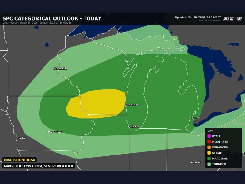
Forecast data shows a broad area of storm activity stretching from Iowa through Wisconsin, Illinois, and into Michigan, placing multiple major cities under a risk zone.
The most concentrated threat area is centered over parts of western and central Wisconsin, where conditions are most favorable for severe storm development. Surrounding regions, including Chicago, Milwaukee, and areas near Detroit, remain under a broader risk for thunderstorms capable of producing damaging impacts.
While the overall classification remains in the lower-tier severe categories, the specific threat of hail and isolated intense storms makes this setup notable.
Supercells Expected to Develop After Sunset
Storm timing will be critical, with supercells likely forming around and after sunset across the region. These storms are expected to organize quickly in an environment supportive of strong updrafts.
This setup increases the potential for:
- Large hail capable of damaging vehicles
- Strong, gusty winds within storm cores
- Localized intense storm cells rather than widespread severe lines
The evening timing may also increase risks, as storms could develop when visibility is lower and residents are less prepared.
Key Cities and Areas in the Impact Zone
Several major Midwest locations fall within the risk corridor, including:
- Milwaukee, Wisconsin
- Chicago, Illinois
- Des Moines, Iowa
- Detroit, Michigan
The highlighted risk zone suggests the greatest concentration of severe potential lies between eastern Iowa and southern Wisconsin, but impacts could extend outward depending on storm development.
Why This Setup Raises Concern
The combination of atmospheric instability and developing storm structures supports the formation of supercells, which are known for producing more intense and localized severe weather.
With over 14 million people in the risk area, even isolated storms could affect a large number of communities. The emphasis on hail risk makes this system particularly concerning for property damage, especially vehicles left outdoors.
Residents Urged to Stay Alert Through Evening Hours
Residents across the Midwest are encouraged to remain weather-aware as conditions evolve throughout the day. Monitoring updates and preparing for rapidly changing weather will be important, especially during the evening window when storms are expected to peak.
This severe weather pattern may continue beyond today, signaling the start of a more active stretch across the region. Stay with NapervilleLocal.com for continuing coverage and real-time updates as severe storms develop across Wisconsin, Illinois, Iowa, and Michigan.

I’ve lived in Naperville long enough to see how quickly our community changes — from new developments downtown to sudden shifts in our Midwest weather. Reporting on Naperville news and daily forecasts gives me the chance to keep neighbors informed about what really matters. My goal is simple: deliver clear, timely updates so you always know what’s happening in our city and what to expect from the skies above.