
Wisconsin, Iowa, Illinois and Michigan Brace for Overnight Hail Storms With 2 Inch Stones Possible From Milwaukee to Chicago and Detroit
MILWAUKEE, WISCONSIN — A significant overnight severe weather threat is expected to develop across parts of Wisconsin, Iowa, Illinois, and Michigan, with storms capable of producing large hail — including isolated stones exceeding 2 inches in diameter.
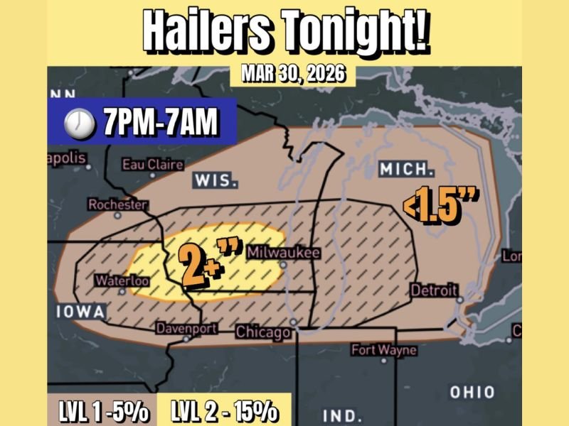
The risk window is expected to begin around 7 PM and continue through 7 AM, with storms forming after sunset and tracking eastward across the region.
Hail Threat Focused Across Southern Wisconsin and Eastern Iowa
Forecast data highlights a concentrated zone of higher hail potential stretching from eastern Iowa into southern Wisconsin, including areas near Waterloo and Milwaukee.
Within this corridor, storms could produce:
- Hail larger than 2 inches in diameter in isolated spots
- Frequent smaller hail events under 2 inches across a broader area
- Rapid storm intensification due to strong atmospheric instability
This region represents the highest concern for significant hail damage, especially to vehicles and exposed property.
Storms Expected to Develop After Sunset
Unlike daytime severe setups, this event is expected to unfold primarily overnight. Storms are likely to initiate in eastern Iowa near or just after sunset, then move east into Wisconsin, Illinois, and eventually Michigan overnight.
Cities along the projected storm path include:
- Milwaukee, Wisconsin
- Chicago, Illinois
- Davenport, Iowa
- Detroit, Michigan
The nighttime timing increases risk, as storms may intensify while many residents are asleep.
Broader Region Faces Moderate Hail Risk
Outside the highest-impact zone, a wider area covering Illinois, lower Michigan, and surrounding regions is still expected to see hail, though generally smaller in size.
Forecast projections indicate:
- Hail up to around 1.5 inches possible in parts of Michigan
- A widespread zone of lower-end hail risk extending into northern Illinois and surrounding states
- Storm probabilities ranging from 5% to 15%, indicating scattered but potentially impactful activity
Even smaller hail can cause damage when combined with strong winds and repeated storm activity.
Why Conditions Support Large Hail Development
The setup includes strong updraft potential and steep lapse rates, which allow hailstones to grow larger as they cycle within storm cores. Elevated storm bases interacting with colder upper-level air will further support hail formation, increasing the chances of larger stones reaching the ground.
Overnight Impacts and Safety Concerns
Residents across the impacted region should prepare for:
- Sudden loud hail impacts overnight
- Potential vehicle damage if left outdoors
- Brief but intense storm bursts with lightning and gusty winds
Because storms will occur during overnight hours, having alerts enabled is critical.
Active Pattern Continues Into Following Days
This event is part of a broader multi-day severe weather pattern across the Midwest. How these storms evolve overnight could influence additional storm chances in the coming days.
Conditions will continue to be monitored as this system progresses across Wisconsin, Iowa, Illinois, and Michigan. Stay with NapervilleLocal.com for continued severe weather updates and real-time coverage.

I’ve lived in Naperville long enough to see how quickly our community changes — from new developments downtown to sudden shifts in our Midwest weather. Reporting on Naperville news and daily forecasts gives me the chance to keep neighbors informed about what really matters. My goal is simple: deliver clear, timely updates so you always know what’s happening in our city and what to expect from the skies above.