
Heavy Rainfall Threat Building Across Texas, Louisiana, and Mississippi Next Week
DALLAS — Forecasters are warning that a multi-day heavy rain event could impact Texas, Louisiana, Mississippi, and parts of the Southeast beginning Monday, November 18, as a strong weather system sweeps across the Southern Plains and into the Gulf states.
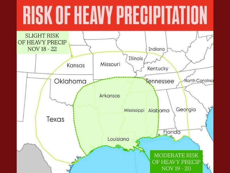
According to the latest projections, areas across eastern Texas, southern Arkansas, northern Louisiana, and central Mississippi face a slight to moderate risk of receiving more than one inch of rain within a 24-hour period, raising concerns for localized flooding and travel disruptions.
Timing and Risk Areas
Meteorologists with national weather outlooks say the heaviest rainfall will likely occur between November 19–20, with precipitation lingering across parts of the region through Friday, November 22.
- Slight Risk (Nov 18–22): Covers most of Texas, Oklahoma, Arkansas, and Louisiana.
- Moderate Risk (Nov 19–20): Focused over Louisiana, Mississippi, and parts of southern Alabama and the Florida Panhandle.
Rainfall totals could exceed 2–3 inches in localized areas, especially near the Gulf Coast, where moisture from the Gulf of Mexico is expected to enhance storm intensity.
“We’re looking at a classic late-autumn setup,” one meteorologist said. “Moisture from the Gulf will meet colder air from the Plains, creating a zone of persistent, heavy rainfall. Flash flooding will be possible in low-lying and urban areas.”
Potential Flooding and Travel Impacts
Forecasters warn that rainfall rates could be heavy enough to cause minor flooding along creeks, rivers, and roadways. Urban centers such as Houston, Jackson, and Little Rock may experience ponding on roads and slower commutes during peak rain periods.
Rural regions, especially those with clay soils or poor drainage, are also at risk of short-term runoff flooding. Emergency management officials in affected states are urging residents to check drainage systems, avoid flooded roadways, and stay tuned to local forecasts.
Weather Pattern Driving the System
The rain event is being triggered by an upper-level trough sweeping across the western United States, which will pull Gulf moisture northward into the Southern Plains. As the system strengthens, it is expected to bring widespread cloud cover, thunderstorm activity, and cooler temperatures across much of the South.
Meteorologists note that while the rain will bring much-needed moisture to drought-affected regions of Texas and Oklahoma, the intensity and duration of the event could lead to localized flooding, particularly where soils are already saturated from earlier showers.
Looking Ahead
After the system exits late next week, cooler and drier air is expected to move in behind it, offering a brief break before another potential storm system approaches closer to Thanksgiving week.
Residents across Texas, Louisiana, Mississippi, Alabama, and nearby states are encouraged to stay alert to updated forecasts and local advisories as the system develops.
Stay updated with live rain forecasts and flood advisories for your area at NapervilleLocal.com.

I’ve lived in Naperville long enough to see how quickly our community changes — from new developments downtown to sudden shifts in our Midwest weather. Reporting on Naperville news and daily forecasts gives me the chance to keep neighbors informed about what really matters. My goal is simple: deliver clear, timely updates so you always know what’s happening in our city and what to expect from the skies above.