
Isolated to Scattered Storms With Gusty Winds Heavy Rain and Flooding Risk Targeting Southwest North Carolina Including Asheville Charlotte and Fayetteville
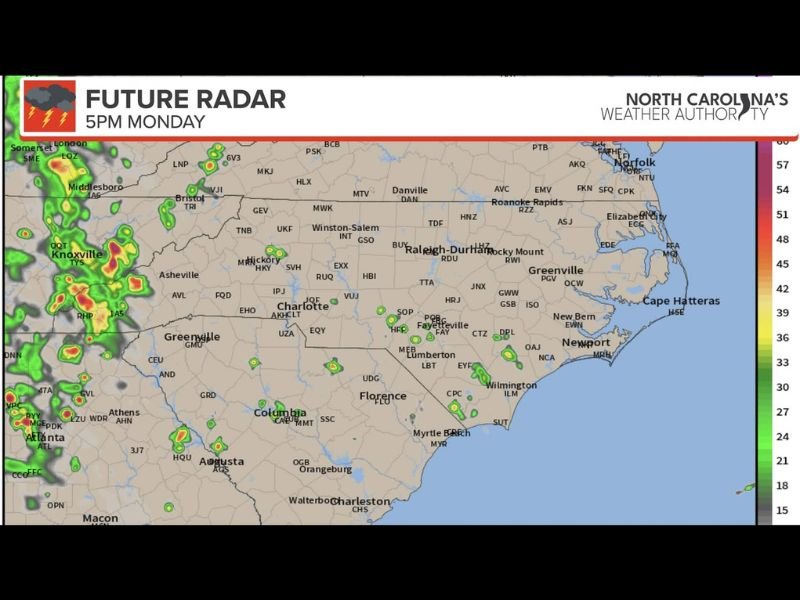
NORTH CAROLINA — Isolated to scattered showers and thunderstorms are on tap for North Carolina Monday afternoon and evening, with the southwestern portion of the state carrying the most concentrated storm coverage and the greatest potential for gusty winds and heavy rainfall. The future radar image valid 5 PM Monday shows the most intense returns concentrated across the western North Carolina mountain corridor near Asheville and Hickory, with scattered lighter activity extending across central and eastern portions of the state.
Localized flooding cannot be ruled out in poorly drained areas across the southwest where the heaviest rainfall is expected to concentrate.
Southwest North Carolina Carries the Best Storm Coverage Monday Evening
The SW section of the state is the primary focus for Monday afternoon and evening storm activity, with the 5 PM future radar depicting the most organized and intense returns clustered across the Asheville, Hickory, and surrounding western mountain communities. These storms could produce gusty winds and locally heavy rainfall that pushes the flooding threshold in areas with poor drainage or already saturated ground.
Elsewhere across the state, storm coverage is expected to be very hit or miss with most locations seeing little to no impact.
Central and Eastern North Carolina See Isolated Activity Through the Afternoon
The future radar imagery shows scattered isolated storm returns dotting central North Carolina including the Raleigh-Durham, Charlotte, and Fayetteville corridors through the afternoon and into the evening hours. These isolated cells will be garden-variety hit or miss thunderstorms rather than an organized or widespread severe weather event.
Communities near Wilmington, New Bern, and the coastal plain also carry a small chance for isolated afternoon activity based on the radar simulation.
Storm Coverage Continues Through Tuesday and Wednesday Across the State
The extended future radar panels show storm chances persisting through Tuesday and Wednesday across North Carolina, with coverage remaining scattered rather than widespread during this period. The pattern supports daily afternoon and evening storm development through midweek before any significant change arrives. Residents with multi-day outdoor plans should monitor the daily forecast each morning for the latest storm timing and coverage details. Stay with NapervilleLocal.com for the latest weather updates and local forecast coverage.

I’ve lived in Naperville long enough to see how quickly our community changes — from new developments downtown to sudden shifts in our Midwest weather. Reporting on Naperville news and daily forecasts gives me the chance to keep neighbors informed about what really matters. My goal is simple: deliver clear, timely updates so you always know what’s happening in our city and what to expect from the skies above.