
Major Snowstorm to Blanket New Mexico and Colorado Mountains with Up to 18 Inches Expected in Higher Peaks
SANTA FE, NEW MEXICO — A strong winter storm is taking aim at the mountains of New Mexico and Colorado, with forecasters warning of heavy snow, hazardous travel, and significant mountain accumulations through Thursday.
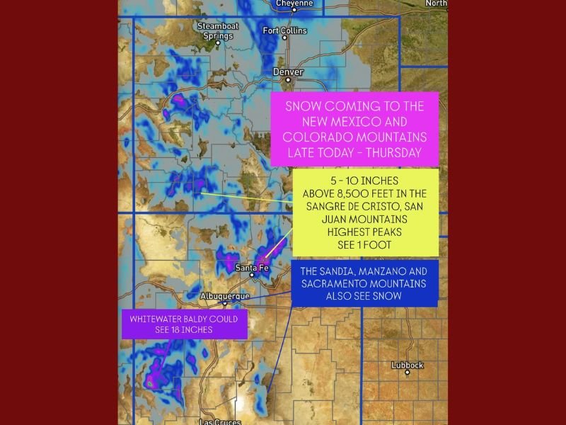
The system is expected to drop 5 to 10 inches of snow across most elevations above 8,000 feet, with the heaviest snow likely in the Sangre de Cristo and San Juan Mountains, where totals could reach up to one foot. Some localized peaks, such as Whitewater Baldy, could see as much as 18 inches of snow.
Heaviest Snowfall Expected in Northern and Southwestern Ranges
Forecasters say a surge of cold air moving in behind the system will enhance snowfall across northern and southwestern parts of both states. The San Juan Mountains in southwestern Colorado and the Sangre de Cristo range in northern New Mexico will likely see the most intense snow rates.
“This storm has all the ingredients for a significant high-elevation snow event,” meteorologists said Wednesday. “Travel could become dangerous in mountain passes as snow continues to pile up through Thursday morning.”
Central and Southern Peaks Also in Line for Snow
Snow isn’t confined to the northern areas. Central and southern ranges — including the Sandia, Manzano, and Sacramento Mountains — will also receive measurable snow, though totals will be slightly lower at 3 to 6 inches.
Travelers in Santa Fe, Taos, and Durango are being urged to monitor road conditions closely, particularly along mountain highways and passes where visibility could drop quickly due to heavy snow.
More Snow Possible by Late Weekend
Meteorologists are already tracking another potential snowmaker expected to arrive late this weekend into early next week, bringing another wave of moisture and reinforcing cold air.
Residents planning holiday travel should check local forecasts and prepare for winter driving conditions, particularly above 8,000 feet.
Stay connected with NapervilleLocal.com for continuing updates on the Southwest snow pattern and potential travel impacts through Thanksgiving week.

I’ve lived in Naperville long enough to see how quickly our community changes — from new developments downtown to sudden shifts in our Midwest weather. Reporting on Naperville news and daily forecasts gives me the chance to keep neighbors informed about what really matters. My goal is simple: deliver clear, timely updates so you always know what’s happening in our city and what to expect from the skies above.