
Two Fatalities Reported After Deadly Supercell Brings Baseball-Size Hail, 90 MPH Winds, and Tornadoes From Wichita Falls to Dallas
NORTH TEXAS — A violent supercell thunderstorm broke through the atmospheric cap near Wichita Falls around 5:30 PM Saturday evening and tracked southeast all the way to the Dallas area, leaving a trail of destruction and two confirmed fatalities in its path. The storm rapidly intensified after initiation, producing baseball-size hail, destructive winds up to 90 miles per hour in Springtown, and one or two tornadoes along its track. One person died in Runaway Bay and one person died in Springtown as a result of the severe weather.
Supercell Rapidly Intensified After Breaking Cap Near Wichita Falls Saturday Evening
The storm initiated near Wichita Falls shortly after 5:30 PM and turned severe almost immediately, dropping baseball-size hail within a short period of development. It tracked southeastward through the region, gaining strength as it moved through communities including Montague, Decatur, and Weatherford before pushing into the Dallas metropolitan area.
The speed and intensity with which the storm developed left little time for residents along its path to seek adequate shelter. Radar data shows a concentrated and powerful storm signature tracking through the western Dallas-Fort Worth corridor and into the heart of the metroplex during the evening hours.
Two Fatalities Confirmed in Runaway Bay and Springtown Along the Storm’s Path
Two lives were lost as a direct result of Saturday evening’s severe weather, with one fatality confirmed in Runaway Bay and a second in Springtown. Springtown also recorded the most extreme wind damage along the track, where gusts reached up to 90 miles per hour and caused destructive impacts to structures and infrastructure in the area.
The loss of life underscores the extreme and rapidly evolving nature of the storm, which gave communities along its path limited time to react. Damage assessments across the affected corridor from Wichita Falls through the Dallas area are ongoing as officials survey the scope of destruction left behind.
Second Supercell Strikes Early This Morning From Denison to Wolfe City
A separate and dangerous supercell moved through the region early Sunday morning, tracking from Denison toward Wolfe City and producing hail measuring 3 to 4 inches in diameter in Whitewright. This second storm added to an already significant severe weather event across North Texas, extending large hail impacts into communities north and east of the Dallas metro.
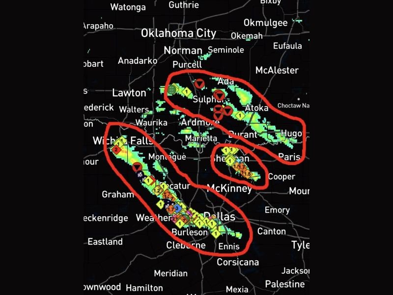
Radar imagery shows multiple tornado and severe thunderstorm warning markers across a broad swath from southern Oklahoma through north Texas, reflecting the widespread and multi-storm nature of the overnight and early morning severe weather activity.
Damage Reports Stretch From Southern Oklahoma Through the Dallas Metroplex
Storm reports on radar imagery show a concentrated cluster of hail and tornado reports stretching from the Ada and Sulphur area in southern Oklahoma southward through Ardmore, Marietta, and into the Dallas and Burleson corridor. Multiple large hail markers and tornado icons are visible across this entire track, indicating a widespread and destructive severe weather footprint affecting both states.
Residents across the affected communities are urged to document damage and contact local emergency management officials. Anyone in need of assistance following storm impacts should reach out to local authorities as damage survey teams continue working through the affected areas. Stay with NapervilleLocal.com for the latest weather updates and local forecast coverage.

I’ve lived in Naperville long enough to see how quickly our community changes — from new developments downtown to sudden shifts in our Midwest weather. Reporting on Naperville news and daily forecasts gives me the chance to keep neighbors informed about what really matters. My goal is simple: deliver clear, timely updates so you always know what’s happening in our city and what to expect from the skies above.