
Freeze Warning Issued for North Florida and Southeast Georgia With Overnight Lows Expected Near 30°F
FLORIDA — The National Weather Service has issued a Freeze Warning for portions of North Florida and Southeast Georgia overnight Friday into early Saturday morning, as temperatures are expected to fall into the upper 20s and low 30s. The warning covers areas from Gilchrist County northward, extending into Southeast Georgia west of Interstate 95, including cities near Jacksonville, Gainesville, and Waycross.
The cold snap marks one final push of Arctic air before a gradual warming trend begins later this weekend. Residents in the affected areas are advised to protect sensitive plants, pets, and outdoor plumbing as subfreezing temperatures could cause damage to vegetation and exposed pipes.
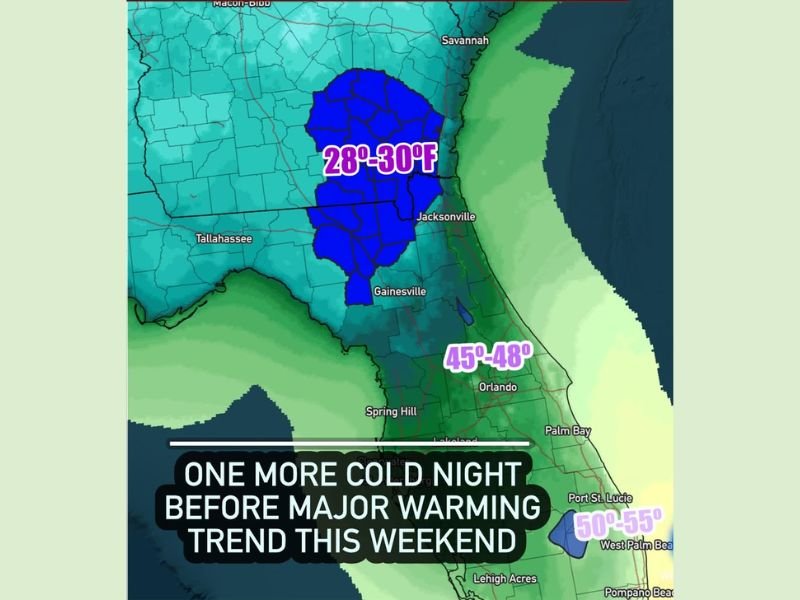
Temperatures to Drop to 28–30°F Overnight
Meteorologists expect temperatures to bottom out between 28°F and 30°F in the dark-blue shaded regions on forecast maps. The freeze warning will remain in effect from 2 a.m. to 8 a.m. Saturday, November 29.
Areas farther south, including Orlando, Spring Hill, and coastal cities along Central Florida, will remain milder with lows ranging between 45°F and 48°F. South Florida will stay even warmer, with overnight lows near 50°F to 55°F along the coast.
“This will be the coldest night of the week for northern Florida and southern Georgia,” forecasters said Friday. “Freezing temperatures may last for several hours in low-lying and inland areas before sunrise.”
Residents Urged to Take Precautions
Officials recommend the following precautions to minimize freeze-related impacts:
- Bring plants indoors or cover them with breathable fabric to prevent frost damage.
- Wrap exposed pipes and outdoor spigots to prevent freezing and bursting.
- Bring pets inside and ensure livestock have access to shelter and unfrozen water.
- Check on elderly neighbors and individuals without adequate heating.
Road conditions are not expected to be hazardous since skies will remain mostly clear and winds light, but early-morning frost may still form on bridges and overpasses.
Cold Snap to End With Weekend Warm-Up
Forecasters say this will likely be the final freeze of the current cold stretch, as a warming trend begins Saturday afternoon and continues into Sunday. Daytime highs are expected to rebound into the 60s and 70s across much of Florida by Sunday, marking a return to more typical late-November weather.
“The Arctic air mass responsible for this freeze will shift eastward, allowing milder Gulf air to return,” meteorologists explained. “By Sunday, many areas will feel a 20-degree temperature jump compared to early Saturday morning.”
Regional Outlook
- North Florida & Southeast Georgia: Overnight lows 28–30°F; freeze warning in effect until 8 a.m. Saturday.
- Central Florida: Lows in the mid-40s, cold but above freezing.
- South Florida: Coastal lows near 50–55°F with no freeze concerns.
This freeze event follows a week of cold weather across the Southeast as the region transitions into its early winter pattern.
Stay connected with NapervilleLocal.com for continued updates on weather alerts, temperature shifts, and forecast changes as conditions improve through the weekend.

I’ve lived in Naperville long enough to see how quickly our community changes — from new developments downtown to sudden shifts in our Midwest weather. Reporting on Naperville news and daily forecasts gives me the chance to keep neighbors informed about what really matters. My goal is simple: deliver clear, timely updates so you always know what’s happening in our city and what to expect from the skies above.