
Early December Snow System to Bring 1–3 Inches Across Midwest and Up to 6 Inches in Northeast as Winter Weather Intensifies
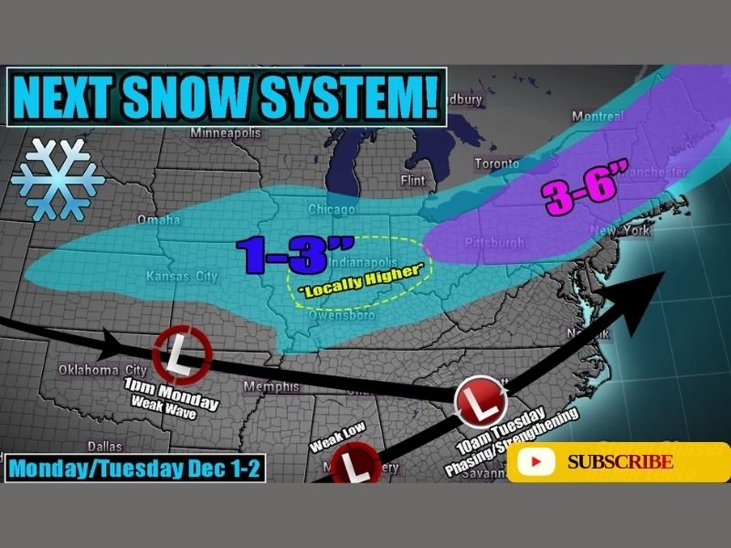
CHICAGO — The first week of December is shaping up to bring another round of wintry weather across the Midwest and Northeast as a new snow system sweeps through the region Monday into Tuesday, dropping a fresh coating of 1–3 inches of snow for many areas and up to 6 inches in the Northeast.
According to meteorologist Adam Lucio, the system will move quickly across the Central Plains and Great Lakes beginning late Monday, producing widespread light to moderate snowfall on top of what already blanketed the ground from last weekend’s storm.
Fresh Snowfall for Midwest Cities, Including Chicago and Indianapolis
The Monday-Tuesday snow wave is expected to track from Kansas and Missouri into Illinois, Indiana, and Ohio, spreading a broad area of snow accumulation across the region.
Forecast models suggest the following accumulation outlook:
- Chicago, IL: 1–3 inches possible
- Indianapolis, IN: 1–3 inches, with locally higher totals
- Kansas City, MO: Up to 1 inch
- Cleveland, OH: 2–4 inches possible by early Tuesday
- Detroit, MI: 2–3 inches likely
A weak low-pressure system forming over Oklahoma will move northeast into the Ohio Valley, producing steady snowfall during the late-night and early morning hours.
The snow will then phase with a stronger low emerging from the Southeast, deepening the storm and increasing snowfall potential as it reaches the Appalachians and Northeast by Tuesday.
Heavier Snow Expected in the Northeast
By Tuesday morning, the system will begin to intensify along the East Coast, delivering heavier snow totals for parts of Pennsylvania, New York, and New England. Forecast projections show 3–6 inches possible from Pittsburgh through New York City and into southern New England.
This strengthening phase could create commuting hazards across major northeastern cities during the Tuesday morning rush, especially as cold air reinforces snowfall over the region.
Midwest Drivers Urged to Use Caution
While this will not be a blockbuster snowstorm, travel impacts are expected across much of the Midwest Monday night into early Tuesday, particularly along Interstates 55, 65, 70, and 80.
Light snow accumulation combined with subfreezing road temperatures could lead to slick and icy surfaces, especially during overnight hours.
Road maintenance crews are preparing for pre-treatment operations, and residents are advised to allow extra travel time and remain alert to changing road conditions.
Winter Pattern Likely to Continue
Meteorologists note that this early-December system signals a continuation of an active winter pattern, with additional snow chances likely across the Midwest through the first half of the month.
“The next system looks to reinforce the winter trend that’s been building since Thanksgiving,” forecasters said. “We’re expecting more waves of light to moderate snow across the central and northern U.S. through mid-December.”
Residents in both the Midwest and Northeast should continue to monitor local forecasts for timing adjustments as this system approaches.
Stay updated on local winter storm developments, travel impacts, and regional forecasts by visiting NapervilleLocal.com.

I’ve lived in Naperville long enough to see how quickly our community changes — from new developments downtown to sudden shifts in our Midwest weather. Reporting on Naperville news and daily forecasts gives me the chance to keep neighbors informed about what really matters. My goal is simple: deliver clear, timely updates so you always know what’s happening in our city and what to expect from the skies above.