
Strong Cold Front Sweeps Across Texas, Driving Temperatures 15–20°F Below Normal as Arctic Air Reaches the Gulf
DALLAS, TEXAS — Another strong Arctic cold front is surging across Texas this weekend, delivering a deep chill that will drop temperatures 15 to 20 degrees below average and send brisk north winds all the way down to the Gulf Coast.
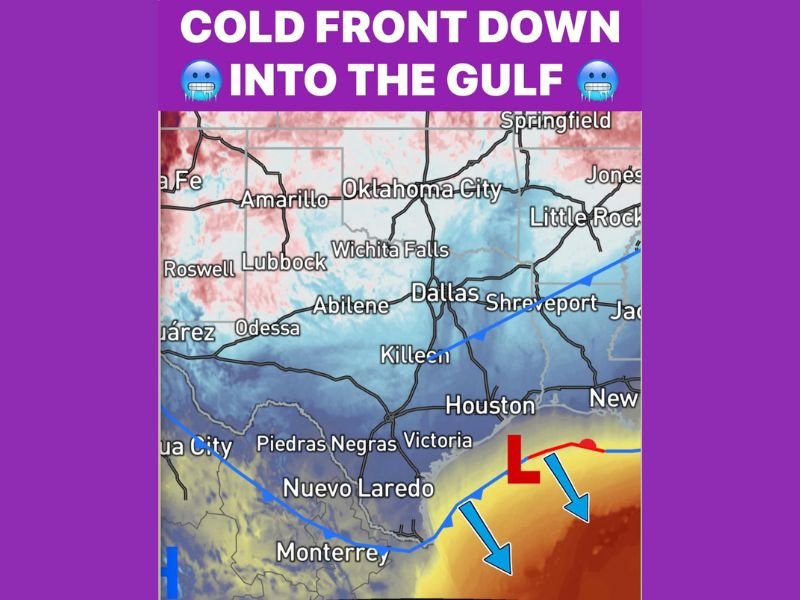
Meteorologists say the front, which began pushing through the Panhandle late Saturday, will continue southward through Sunday, reaching Houston, Victoria, and the coastal plains by Sunday night. The surge of cold, dry air will bring a sharp temperature drop across much of the state, with overnight lows dipping into the 20s and 30s in northern and central Texas.
Arctic Air Extends South to the Gulf
Forecast models from the National Weather Service show the cold front reaching deep into the Gulf of Mexico by early Monday morning, marking one of the most widespread temperature drops so far this December.
“Cold air has firmly taken over,” forecasters said Saturday night. “This front will push through the entire state, leaving much of Texas 15–20°F below normal through Monday morning.”
On the weather map, a strong north-to-south pressure gradient can be seen funneling Arctic air through major cities including Dallas, Austin, San Antonio, and Houston, before spilling over the Gulf waters. The coldest readings will occur early Monday, when wind chills fall into the teens across North Texas and into the low 30s along the coast.
Weekend Forecast: Widespread Chill, Clear Skies
- Dallas–Fort Worth: Highs around 43°F Sunday, lows near 28°F by early Monday.
- Austin–San Antonio: Highs in the upper 40s, lows in the low 30s.
- Houston and Gulf Coast: Daytime highs near 50°F, dipping into the upper 30s overnight.
While skies will remain mostly clear after the front’s passage, winds from the north at 15–25 mph will make it feel considerably colder. Meteorologists expect frost advisories to be possible across central and southeast Texas by early Monday morning.
Early Week Outlook: Cold Start Before Gradual Warmup
The Arctic air mass will hold firm through Monday, maintaining unseasonably cold conditions across the entire region. Temperatures are expected to remain well below normal until Tuesday, when a gradual warmup begins as winds shift to the south.
By midweek, highs will rebound into the 50s and 60s across most of Texas, but overnight lows will still remain chilly. Forecasters note that another weak front may approach the state later in the week, though not nearly as intense as the current system.
Safety and Preparedness Tips
Officials urge Texans to take precautions as temperatures plunge:
- Protect pets, pipes, and plants from freezing conditions.
- Dress in layers when venturing outside, especially during early morning hours.
- Use caution with space heaters and fireplaces to prevent household fires.
- Check on elderly neighbors or those without reliable heat.
Residents across central and south Texas should also prepare for gusty north winds and chilly mornings before the return of milder conditions by Tuesday.
For the latest weather alerts and regional updates, stay tuned to NapervilleLocal.com.

I’ve lived in Naperville long enough to see how quickly our community changes — from new developments downtown to sudden shifts in our Midwest weather. Reporting on Naperville news and daily forecasts gives me the chance to keep neighbors informed about what really matters. My goal is simple: deliver clear, timely updates so you always know what’s happening in our city and what to expect from the skies above.