
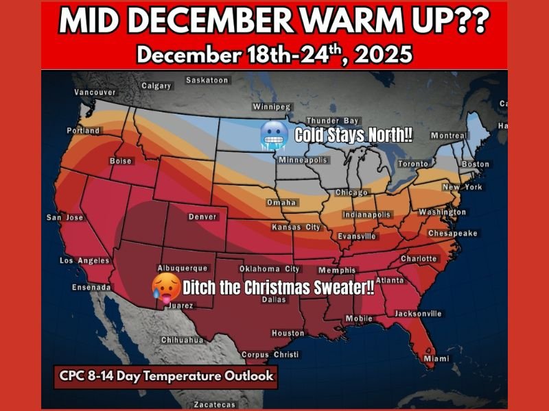
Sharp Mid-December Warmup Expected Across Most of the United States as Long-Range Outlook Shows Widespread Above-Normal Temperatures From December 18–24
United States — A major pattern shift is forecast to unfold across the nation beginning late next week, bringing a significant mid-December warmup to much of the country. According to the latest 8–14 Day Temperature Outlook from the Climate Prediction Center, temperatures from December 18–24 are expected to run well above normal across the South, Midwest, East Coast, and the central United States. Only parts of the northern tier, including regions near the Canadian border, are expected to hold onto colder-than-average conditions.
Majority of the Country to Experience Above-Normal Temperatures
The new long-range outlook highlights an expansive area of above-normal warmth stretching from California through the central Plains and into the Midwest, Great Lakes, and East Coast. A dominant ridge pattern is expected to set up over the continental United States, steering warmer air northward and suppressing typical December cold.
States including Illinois, Indiana, Ohio, Missouri, Kansas, Kentucky, Tennessee, Arkansas, Georgia, the Carolinas, and the Mid-Atlantic all fall under the high-probability warm zone, with temperatures that may reach the 60s and even low 70s in some southern locations. The Southwest and Deep South may experience even warmer conditions, with some areas rising into the 70s and 80s, far above seasonal averages for late December.
Coldest Air Remains Locked in the Northern Tier
While most of the country trends warmer, the CPC outlook shows the coldest conditions holding near the U.S.–Canada border, particularly across North Dakota, Minnesota, and northern Montana. These areas are expected to remain closer to seasonal norms or slightly below normal. However, the cold does not appear likely to push south in a meaningful way during this period.
This north–south temperature divide reinforces the strength of the atmospheric ridge controlling the national pattern.
What This Means for Holiday Weather Expectations
For those hoping for a snowy landscape or a traditional white Christmas, the forecast offers little support for widespread winter conditions during the week leading up to the holiday. Instead, the mild pattern may limit snow chances across many regions, especially in the Midwest, Great Lakes, and East Coast, where above-normal temperatures dominate the long-range outlook.
The warmup may also influence holiday travel, as warmer temperatures could reduce the likelihood of winter storms but may create dense fog, wet roads, and temperature swings in regions transitioning between warm afternoons and cooler nights.
Why the Pattern Flip Is Occurring
Meteorologists attribute the warm surge to a strong upper-level ridge developing over the central and eastern United States. This pattern promotes sinking air, clear skies, and persistent warmth. As the ridge strengthens, colder air is deflected into Canada, decreasing the frequency of Arctic air intrusions into the U.S.
What Residents Should Watch Next
Forecasters will continue monitoring the evolution of the pattern in case colder air attempts to return toward the end of December. For now, the signal remains strong for a nationwide warmup during the December 18–24 timeframe.
For continued updates on national and regional weather trends, visit NapervilleLocal.com.

I’ve lived in Naperville long enough to see how quickly our community changes — from new developments downtown to sudden shifts in our Midwest weather. Reporting on Naperville news and daily forecasts gives me the chance to keep neighbors informed about what really matters. My goal is simple: deliver clear, timely updates so you always know what’s happening in our city and what to expect from the skies above.