
Sharp Mid-December Warm Surge Expected Across Most of the United States From December 15–25 as Long-Range Outlook Shows Strong Temperature
United States — Much of the country is expected to experience a significant warm spell from December 15 through December 25, according to the latest long-range temperature outlook. Meteorologists warn that a developing pattern known as a “blowtorch” setup will bring widespread above-normal temperatures across the central, southern, and eastern United States, sharply reducing the likelihood of a white Christmas for many regions. The warm surge is set to impact nearly every major region except for a small portion of the far Northeast.
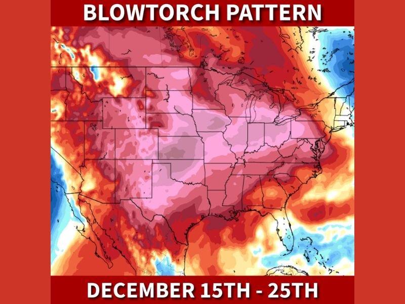
Long-Range Maps Show Strong Warm Anomalies Across Central and Eastern States
The temperature anomaly map highlights an extensive zone of deep red and pink shading, indicating much warmer-than-average conditions stretching from the Rockies through the Plains, Midwest, Great Lakes, Ohio Valley, Mid-Atlantic, and Southeast. This broad coverage suggests a dominant ridge pattern that will keep cold air bottled up in the far northern latitudes.
Meteorologists note that the intensity of the warm signal, combined with its duration, makes it one of the most pronounced early-winter warm anomalies in recent years. Many areas may see temperatures running 10 to 25 degrees above average, with some southern regions potentially climbing into the 70s or even low 80s during the warmest days.
White Christmas Chances Diminish Across the Majority of the Nation
The warm pattern arrives during a critical period for holiday weather expectations. With temperatures trending consistently above normal across the middle and eastern portions of the United States, the probability of snow cover or fresh snowfall decreases sharply for regions including Illinois, Indiana, Ohio, Missouri, Kentucky, Tennessee, and large portions of the Northeast.
Only the far northern tier — particularly parts of New England and areas closest to the Canadian border — may retain enough cold air for traditional winter conditions to develop.
Atmospheric Setup Favors a Persistent Ridge and Limited Arctic Air
Forecasters attribute the pattern to a strong upper-level ridge forming over the continental United States. This configuration suppresses storm development and prevents meaningful Arctic air intrusions. As a result, cold air remains locked in Canada while warm Pacific and Gulf air dominates the lower 48.
This type of pattern tends to persist for several days, meaning the warm anomaly may last straight through Christmas week unless major atmospheric shifts occur.
What Residents Should Watch Going Forward
Residents should keep an eye on updated guidance as models refine the strength and duration of the warm surge. While mild weather may benefit travel and reduce winter storm impacts, it may also bring dense fog, overnight inversions, and reduced air quality in some regions.
For ongoing updates on national temperature trends and seasonal outlooks, visit NapervilleLocal.com for the latest coverage.

I’ve lived in Naperville long enough to see how quickly our community changes — from new developments downtown to sudden shifts in our Midwest weather. Reporting on Naperville news and daily forecasts gives me the chance to keep neighbors informed about what really matters. My goal is simple: deliver clear, timely updates so you always know what’s happening in our city and what to expect from the skies above.