
Texas Braces for Strong Arctic Front as Sunday Temperatures Drop to Freezing With Wind Chills in the Teens Across the DFW Region
TEXAS — A powerful arctic cold front is set to sweep across Texas late Saturday night, sending temperatures tumbling to freezing by early Sunday morning across the Dallas–Fort Worth region and much of North Texas. Forecast models show wind chills falling into the 20s and even the teens in northern counties as the state prepares for its coldest day of winter so far.
Temperatures to Plunge Rapidly After 9 p.m. Saturday
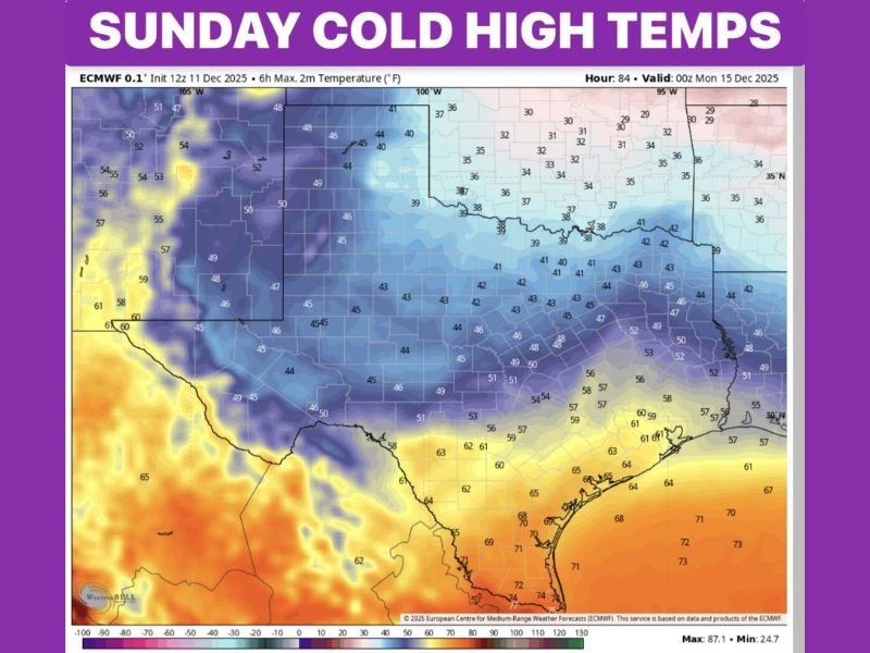
Newest forecast data shows the cold air arriving after 9 p.m. Saturday, quickly dropping temperatures from the 50s and 40s into the upper 20s and low 30s by sunrise Sunday. The ECMWF temperature map highlights widespread cold, with high temperatures struggling to reach 40°F across DFW and surrounding areas.
Cities across North Texas, including Wichita Falls, Denton, McKinney, and Gainesville, are expected to remain locked in the 30s throughout the afternoon, while wind chills stay in the 20s, making it feel significantly colder than actual readings.
The sharp temperature divide across the state is especially notable. While North Texas freezes, South Texas and the Gulf Coast remain much warmer, with highs ranging from the 60s to low 70s in areas including Houston, Corpus Christi, and Brownsville.
Sunday Expected to Be the Coldest Day Yet This Winter
Forecasters warn that Sunday will likely be the coldest day of the winter season so far for the DFW metroplex. Afternoon temperatures failing to climb above 40°F will keep the region well below seasonal averages. Northerly winds will enhance the chill, pushing feels-like temperatures into the upper teens for several northern communities.
Residents across the western counties and the Red River Valley should anticipate bitter conditions, particularly during early morning and late evening hours when wind speeds peak and temperatures bottom out.
This pattern is typical of strong mid-December arctic fronts but still stands out for its severity and the duration of sub-freezing air expected across the northern half of Texas.
Another Hard Freeze Expected Early Monday Morning
The cold air will remain firmly in place through Monday, with morning lows forecast to fall into the 24–30°F range across much of North Texas. This marks the second consecutive freeze for areas such as Dallas, Fort Worth, Arlington, Plano, and Frisco, increasing risks for sensitive vegetation, exposed pipes, and outdoor pets.
While temperatures should gradually recover Monday afternoon, the region will remain cooler than normal, with highs reaching only the mid-40s to low 50s.
Residents are urged to take standard winter precautions, including insulating outdoor faucets, protecting plants, and limiting early-morning outdoor exposure.
As the winter pattern strengthens across multiple states, stay connected to NapervilleLocal.com for more updates on arctic air pushes, temperature swings, and regional cold-weather safety guidance.

I’ve lived in Naperville long enough to see how quickly our community changes — from new developments downtown to sudden shifts in our Midwest weather. Reporting on Naperville news and daily forecasts gives me the chance to keep neighbors informed about what really matters. My goal is simple: deliver clear, timely updates so you always know what’s happening in our city and what to expect from the skies above.