
Late-December Temperature Outlook Shows Major Warmup Across Western, Central, and Southern U.S., While Northeast Faces Colder Conditions Heading Into Christmas Week
United States — A new long-range NOAA AI-GFS temperature anomaly forecast suggests a broad warmup across the western, central, and southern United States leading into the December 21–26 period, while colder-than-normal conditions remain firmly entrenched across the Northeast and parts of eastern Canada. The pattern shift indicates that many regions may experience well-above-normal temperatures before Christmas, though it will not resemble a spring-like warm spell.
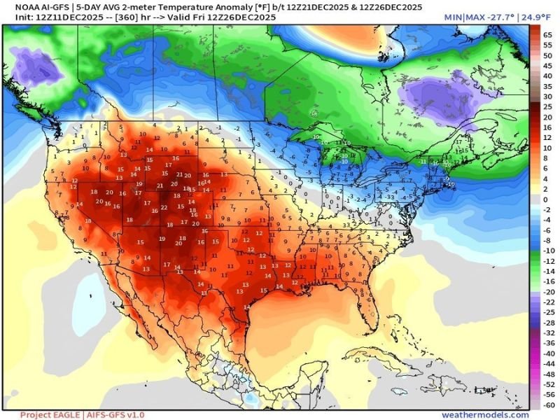
Warm Anomalies Surge Across West, Plains, and Parts of the South
Forecast maps show a large area of 10–20 degree above-normal temperature anomalies stretching from the Pacific Northwest through California, the Rockies, the Plains, and into Texas and the Gulf region. States such as Utah, Colorado, Nevada, Arizona, New Mexico, Oklahoma, Texas, Kansas, and Nebraska appear solidly within the warm anomaly zone.
This pattern suggests that daytime temperatures may feel milder than recent early-season cold, though still appropriate for late December. Weather experts caution that the warmup is relative, meaning temperatures trend warmer than normal but do not equate to T-shirt weather for many regions.
Midwest Sees Moderation but Not a Full Warm Spell
The Midwest and Great Lakes region is shown near the boundary between warm and cold anomalies, with forecast values indicating a slight warmup but still cooler-than-average conditions in some areas. Localized anomalies range from +3°F to +11°F across parts of the central U.S., hinting at milder daytime highs but not a rapid shift toward spring-like weather.
Residents across the Midwest may experience a noticeable improvement from early-December Arctic air, but temperatures remain seasonally chilly.
Northeast Remains Under a Stronger Cold Influence
While much of the country leans warm, the Northeast, Mid-Atlantic, and parts of eastern Canada appear 10–20 degrees below normal for the December 21–26 period. Areas of New York, Pennsylvania, Vermont, New Hampshire, and Maine remain firmly in the cold anomaly zone, with the possibility of reinforcing cold air entering just before Christmas.
This stark contrast underscores a highly divided national temperature pattern, with the West and South warming significantly while the Northeast holds onto deeper winter cold.
What Residents Should Expect Heading Into Christmas Week
Meteorologists advise that the upcoming warmup does not guarantee a mild Christmas for all regions. While the West, Plains, and South show clear signals of above-normal temperatures, the Northeast may experience below-normal highs and increased chances for wintry weather.
Experts recommend monitoring updated forecasts as shorter-range models refine temperature details.
For continuing updates on national temperature trends and holiday weather expectations, visit NapervilleLocal.com.

I’ve lived in Naperville long enough to see how quickly our community changes — from new developments downtown to sudden shifts in our Midwest weather. Reporting on Naperville news and daily forecasts gives me the chance to keep neighbors informed about what really matters. My goal is simple: deliver clear, timely updates so you always know what’s happening in our city and what to expect from the skies above.