
Dangerous Arctic Blast to Bring Life-Threatening -30 to -40 Wind Chills Across Minnesota Saturday Morning
MINNESOTA — Northern parts of the state are bracing for extremely dangerous wind chills ranging from -30°F to nearly -40°F early Saturday, creating conditions that can freeze exposed skin within minutes and pose a serious risk to anyone outdoors.
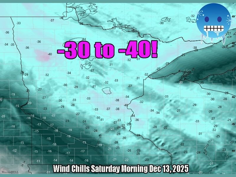
Wind Chill Values Plunge Into Life-Threatening Range
Meteorologists report that an intense Arctic air mass will surge into northern Minnesota late Friday night, setting the stage for one of the coldest wind chill events of the season. Forecast models show widespread readings between -30°F and -40°F, especially across the Iron Range, Boundary Waters region and areas near the Canadian border.
Experts warn that wind chills this low can lead to frostbite in as little as 10 minutes, with hypothermia a real possibility for anyone caught unprepared.
Cold Air Deepens Overnight as Arctic High Pressure Builds
As Arctic high pressure settles over the Upper Midwest, temperatures will fall sharply before sunrise Saturday. Actual air temperatures are expected to drop below zero, and when combined with strong northwest winds, the apparent temperature will collapse into the dangerously low range shown on the latest weather maps.
This type of cold is described by forecasters as the kind that “instantly freezes your nose”, emphasizing how quickly exposed skin can be affected.
Travel and Outdoor Risks Increase Across Northern Minnesota
Wind chills at this level bring significant hazards to drivers, pedestrians and workers. Vehicle breakdowns become more serious in extreme cold, and even short walks from parked cars can be dangerous without adequate winter clothing.
Schools, local agencies and emergency officials typically urge residents to:
- Wear multiple layers, including face protection
- Avoid extended outdoor exposure
- Prepare vehicles with winter emergency kits
- Bring pets indoors immediately
Public safety departments across northern Minnesota are monitoring conditions closely and may issue additional advisories if cold intensifies.
Relief Not Expected Until Later in the Weekend
While temperatures may moderate slightly by Saturday afternoon, early morning hours will pose the most severe threat. The broader cold pattern is expected to linger through the weekend, although wind speeds may ease enough to reduce the most extreme wind chill values.
Forecasters caution that even after the coldest point passes, temperatures will remain below average, and Arctic air could return later in December.
Stay Informed and Stay Safe
Residents in northern Minnesota should monitor updated forecasts and wind chill alerts through the National Weather Service as conditions evolve. The dangerously low wind chills Saturday morning will require caution and proper preparation to avoid injury.
For continuing updates on major weather events across the U.S., stay with NapervilleLocal.com.

I’ve lived in Naperville long enough to see how quickly our community changes — from new developments downtown to sudden shifts in our Midwest weather. Reporting on Naperville news and daily forecasts gives me the chance to keep neighbors informed about what really matters. My goal is simple: deliver clear, timely updates so you always know what’s happening in our city and what to expect from the skies above.