
Washington, Oregon, and Vancouver Island Brace for Dangerous Overnight Wind Gusts Up to 55 mph, Causing Power Outage and Tree Damage Risks
WASHINGTON — Strong winds are expected to intensify overnight into Wednesday morning across Washington, Oregon, and Vancouver Island, with widespread gusts ranging from 40 to 55 mph likely. Forecasters warn that these conditions could easily lead to power outages, uprooted trees, and downed power poles, especially in areas where the soil is already saturated from recent rainfall.
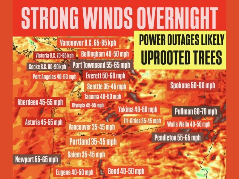
Forecasters Warn of Impactful Overnight Winds
According to the latest wind model guidance and regional alerts, several locations across the Pacific Northwest are positioned to experience the strongest gusts. Cities and regions highlighted include:
Washington
- Seattle: 35–45 mph
- Tacoma: 40–50 mph
- Everett: 50–60 mph
- Olympia: 45–55 mph
- Bellingham: 40–50 mph
- Port Angeles: 40–50 mph
- Yakima: 40–50 mph
- Spokane: 50–60 mph
- Pullman: 60–70 mph
- Walla Walla: 40–50 mph
- Tri-Cities: 35–45 mph
- Pendleton (near WA border): 55–65 mph
Oregon
- Portland: 35–45 mph
- Salem: 35–45 mph
- Eugene: 40–50 mph
- Bend: 40–50 mph
- Astoria: 45–55 mph
- Newport: 55–65 mph
Vancouver Island & Surrounding B.C. Areas
- Vancouver, B.C.: 65–85 kph
- Victoria, B.C.: 70–85 kph
- Sooke, B.C.: 80–90 kph
These wind speeds are strong enough to cause significant travel challenges, scattered outages, and isolated structural damage.
Risk of Uprooted Trees and Infrastructure Damage
Meteorologists caution that saturated soils across the Pacific Northwest will make trees more vulnerable to falling under strong wind gusts. Power lines and poles may also be damaged, potentially leaving thousands without electricity.
Residents are urged to:
- Secure outdoor objects
- Prepare for potential outages
- Avoid parking vehicles under large trees
- Stay updated with local forecasts through the early morning hours
Timing of the Event
The most intense wind period is expected from late Tuesday night into Wednesday morning, with the strongest bursts occurring along the Washington coast, higher terrain zones, and valleys experiencing funneling effects.
NapervilleLocal.com will continue monitoring updates and provide additional details if forecasts change. Stay weather-aware and take precautions to stay safe during this overnight wind event.

I’ve lived in Naperville long enough to see how quickly our community changes — from new developments downtown to sudden shifts in our Midwest weather. Reporting on Naperville news and daily forecasts gives me the chance to keep neighbors informed about what really matters. My goal is simple: deliver clear, timely updates so you always know what’s happening in our city and what to expect from the skies above.