
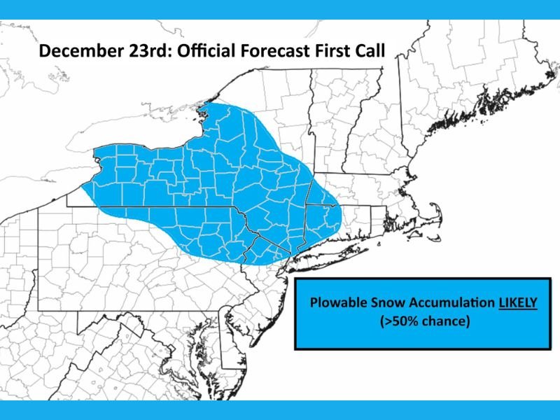
Meteorologists Warn of Plowable Snow Potential on December 23rd Across Parts of Pennsylvania, New York, and the Northeast
Pennsylvania & New York — Meteorologists are monitoring a developing winter system expected to bring plowable snow to portions of Pennsylvania, New York, and surrounding Northeast states on December 23rd, with the greatest likelihood falling between 11 p.m. Monday and 11 a.m. Tuesday. According to forecaster Mark Margavage, areas highlighted in blue on the latest forecast map have a greater than 50% chance of accumulating enough snow to require plowing, while regions outside the zone have a lower but still notable possibility.
Plowable Snow Likely in Core Forecast Area
The early forecast identifies a broad region stretching across central and northern Pennsylvania into southern and central New York state where plowable accumulation appears most likely. These areas will be positioned in the best zone for sustained precipitation, colder temperatures, and adequate moisture necessary for measurable snowfall.
Meteorologist Margavage notes that while some snow may fall outside the blue-shaded region, chances of plowable accumulation in those areas remain below 50% at this stage. However, he emphasized that the forecast is still evolving and that changes are possible before the final outlook is issued.
Timing and Expected Travel Impacts
The expected timeframe—from late Monday night into late Tuesday morning—coincides with both overnight travel and the Tuesday morning commute. Snowfall developing during these hours may create:
- Slippery road conditions and reduced visibility
- Early-morning plowing operations
- Potential delays for holiday travelers
Forecasters urge residents and travelers across the highlighted zone to prepare for disrupted travel, slower driving speeds, and the possibility of snow-covered roads, particularly in higher elevations or rural stretches.
Snowfall Outside the Primary Zone Still Possible
Even though the probability of plowable snow outside the designated region is lower, meteorologists caution that a shift in storm track or temperature profile could expand the risk zone. This is especially true for parts of western New York, northeastern Pennsylvania, and the southern tier of New York, where even modest adjustments in moisture or cold air could lead to measurable snowfall.
Forecaster Mark Margavage emphasized that nothing is set in stone, and additional data arriving overnight will clarify how far the snow shield may extend. A final, more precise update is expected tomorrow.
Monitoring Conditions Ahead of the Holiday
With Christmas week approaching, the timing of this system may influence travel plans across several Northeast states. Residents are encouraged to follow updated forecasts, prepare vehicles for winter driving, and allow extra time for both early Tuesday and midday travel. For continuing updates on the developing December 23rd snow event and other winter weather systems, visit NapervilleLocal.com for the latest reporting.

I’ve lived in Naperville long enough to see how quickly our community changes — from new developments downtown to sudden shifts in our Midwest weather. Reporting on Naperville news and daily forecasts gives me the chance to keep neighbors informed about what really matters. My goal is simple: deliver clear, timely updates so you always know what’s happening in our city and what to expect from the skies above.