
Strong Tornado Tennis Ball Hail and 70mph Winds Targeting Nebraska and Iowa Including Omaha Lincoln Sioux City and Council Bluffs From 4PM to 10PM Monday May 18
NEBRASKA — A significant severe weather threat remains in place for Monday, May 18, 2026 across Nebraska and southwest Iowa despite last night’s storms helping to quell the threat slightly. The primary window runs from roughly 4 PM to 10 PM, starting near the Kansas border and lifting northward through the Omaha metro through the evening hours. A strong tornado is possible south of I-80, with tennis ball size hail and 70 mph wind gusts possible across the broader risk zone with the strongest storms.
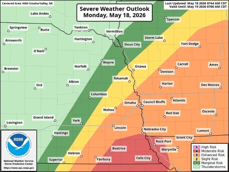
Strong Tornado Most Likely South of I-80 From 4PM Through Evening Hours
The best tornado odds today are focused south of I-80 where atmospheric energy remains most favorable for rotating storm development. The Enhanced and Moderate Risk zones covering Beatrice, Falls City, Nebraska City, Fairbury, and the Lincoln corridor carry the highest tornado confidence during the afternoon and evening window.
Storms are expected to initiate near the Kansas border before lifting northward, giving the southern communities the earliest and potentially most dangerous storm exposure today.
Tennis Ball Hail and 70mph Gusts Possible Across Omaha Council Bluffs and Sioux City
The broader Enhanced and Slight Risk zones covering Omaha, Council Bluffs, Wahoo, Columbus, and Sioux City carry significant hail and wind threats even where tornado potential is lower. Tennis ball size hail up to the size of tennis balls and wind gusts reaching 70 mph are possible with the strongest storms tracking through this corridor during the 4 PM to 10 PM window.
School dismissal in the metro area is unlikely to be directly impacted as the threat is expected to remain south of the area during afternoon hours before lifting north.
Marginal and Slight Risk Extends Through Des Moines Fort Dodge and Ames Iowa
The yellow Slight and green Marginal Risk zones fan northeastward through Des Moines, Fort Dodge, Carroll, and Ames across Iowa. Communities across this wider zone face a lower but still real severe weather threat Monday evening as storms track northward through the region.
All residents from southern Nebraska through the Omaha metro and into southwest Iowa should have weather alerts active and shelter plans confirmed well before 4 PM today. Stay with NapervilleLocal.com for the latest weather updates and local forecast coverage.

I’ve lived in Naperville long enough to see how quickly our community changes — from new developments downtown to sudden shifts in our Midwest weather. Reporting on Naperville news and daily forecasts gives me the chance to keep neighbors informed about what really matters. My goal is simple: deliver clear, timely updates so you always know what’s happening in our city and what to expect from the skies above.