
Florida Forecast Shows Widespread 20s, 30s, and 40s for New Year’s Eve Morning as Strong Year-End Cold Front Pushes South
Florida — A strong year-end cold front is dropping southward across the United States and is expected to bring chilly New Year’s Eve and New Year’s Day morning temperatures statewide, with lows plunging into the 20s across northern Florida, 30s across central regions, and 40s to low 50s across southern counties, according to the latest forecast data. The cool-down will mark one of Florida’s coldest starts to the holiday in recent years.
Year-End Cold Front to Deliver Statewide Temperature Drop by New Year’s Eve
Meteorologists report that the cold front, advancing steadily from the north, will reach Florida just in time to influence New Year’s Eve morning temperatures. Northern parts of the state, including areas near the Georgia border, may experience upper 20s, with central counties dipping into the low to mid-30s.
Farther south — including regions around Tampa, Fort Myers, Naples, and coastal zones — morning lows are projected to fall into the 40s and low 50s, resulting in a noticeably cooler-than-average start to the final day of 2025.
Forecasters highlight that despite the cold mornings, afternoon highs are expected to rebound by 20 to 25 degrees, offering milder conditions by midday. This means 70s for much of South Florida, providing comfortable weather for outdoor holiday plans.
Temperature Breakdown Shows Major Contrast From North to South
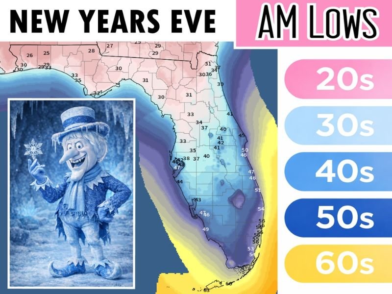
The provided temperature map illustrates a clear north-to-south gradient across Florida, with colors indicating different ranges:
- 20s: Northern Florida counties
- 30s: Central regions around Gainesville, Orlando, and Ocala
- 40s: Inland and coastal zones stretching toward Tampa and Sarasota
- 50s: Southern counties, including Fort Myers and West Palm Beach
- 60s: Extreme southern tip and the Keys
This distribution shows how deeply the cold front will penetrate, reaching far beyond the Panhandle and affecting nearly the entire peninsula. Meteorologists emphasize that even areas unaccustomed to cold mornings should prepare for a significant temperature drop.
New Year’s Day Will Remain Cool in the Morning Before Warming Up
The cold pattern will continue into New Year’s Day morning, with many regions repeating similar low temperatures. However, as with New Year’s Eve, daytime conditions will turn much more pleasant.
Floridians planning outdoor gatherings, travel, or early-morning celebrations should dress appropriately for the unseasonably cold sunrise hours. Sensitive plants and outdoor animals may require protection in northern and central regions, where temperatures may briefly dip near freezing. Despite the chill, forecasters note that the cold front brings no significant precipitation, making it a dry but cold transition into the new year.
Floridians Encouraged to Prepare for a Frosty Start to the Holiday
While Florida is no stranger to winter cold snaps, the timing of this front — arriving on the final weekend of the year — will create a memorable weather shift for residents. Meteorologists recommend:
- Layering clothing for early-morning activities
- Monitoring updates from local weather offices
- Preparing for 20s–30s if living in northern or central regions
- Expecting cooler-than-normal evenings before New Year celebrations
As the state transitions from December to January, the cold front serves as a reminder that even Florida can feel a touch of winter. For more weather updates, temperature forecasts, and year-end climate coverage, follow NapervilleLocal.com for continuous reporting.

I’ve lived in Naperville long enough to see how quickly our community changes — from new developments downtown to sudden shifts in our Midwest weather. Reporting on Naperville news and daily forecasts gives me the chance to keep neighbors informed about what really matters. My goal is simple: deliver clear, timely updates so you always know what’s happening in our city and what to expect from the skies above.