
North Carolina Sees Milder Monday With Scattered Clouds, Cooler Piedmont Temperatures, and Low 60s Returning to the Southeast
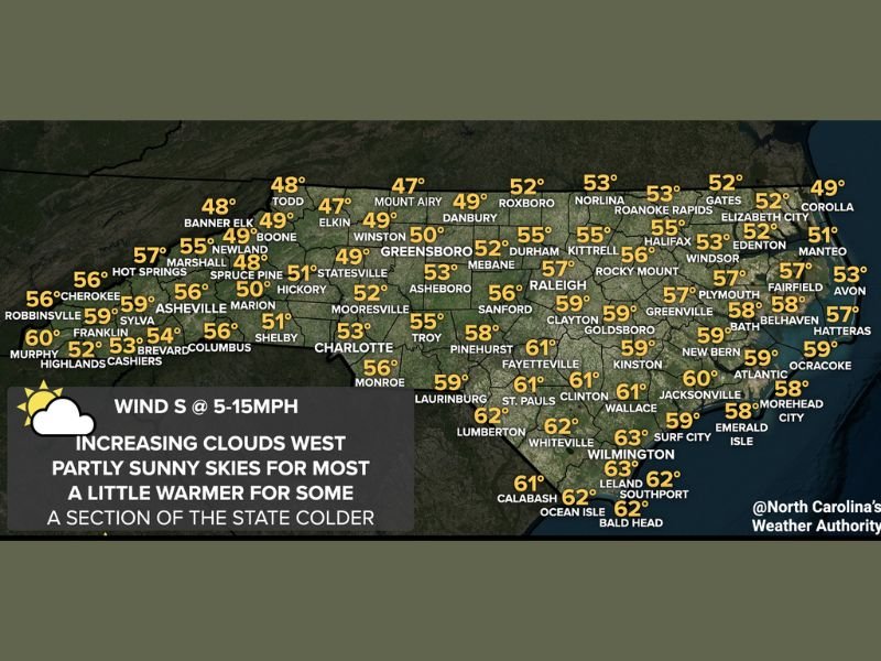
UNITED STATES – Weather conditions across North Carolina are shifting modestly this Monday, bringing a mix of scattered clouds, partial clearing, and a noticeable temperature split across the state, according to the forecast data shown. While much of the state experiences a calm and tranquil day, cloud cover in certain regions is expected to limit how warm temperatures can climb.
Morning conditions feature scattered clouds statewide, with some clearing developing across central and eastern North Carolina as the day progresses. The overall setup points to a quiet weather pattern, with no major systems impacting the region.
Cooler Conditions Hold in the Piedmont and Yadkin Valley
The Piedmont region and parts of the Yadkin Valley are expected to remain cloudier throughout the day, which will keep afternoon highs mainly in the 40s. Locations such as Mount Airy, Elkin, Winston-Salem, and surrounding areas appear to stay on the cooler side compared to the rest of the state.
This increased cloud cover limits daytime heating, preventing temperatures from reaching levels seen farther east and south. Despite the cooler readings, conditions remain dry and stable.
Warmer Temperatures Spread Across Much of the State
Outside the cloudier western and central zones, most of North Carolina is forecast to see highs in the 50s, with low 60s developing across southeastern portions of the state. Cities and towns closer to the coast and southeastern counties stand out as the warmest areas for the day.
The temperature map shows upper 50s to low 60s near Fayetteville, Lumberton, Wilmington, Jacksonville, and surrounding communities, marking a noticeable contrast from the cooler Piedmont. Coastal locations also benefit from partial sunshine, helping temperatures climb slightly higher.
Light Winds and Tranquil Weather Dominate
Winds are shown to be out of the south at 5 to 15 mph, contributing to the gradual warming trend. While clouds increase from the west, most areas still experience partly sunny skies, reinforcing the calm and uneventful nature of the day. Overall, no hazardous weather is indicated, and conditions remain suitable for normal travel and outdoor activities.
Warmer Pattern Expected to Continue
Beyond Monday, the outlook suggests warmer temperatures continuing through the rest of the week across North Carolina. While the image focuses on Monday’s conditions, the broader pattern supports a steady warming trend statewide.
NapervilleLocal.com will continue tracking notable weather developments across the country and provide updates as new forecast data becomes available.

I’ve lived in Naperville long enough to see how quickly our community changes — from new developments downtown to sudden shifts in our Midwest weather. Reporting on Naperville news and daily forecasts gives me the chance to keep neighbors informed about what really matters. My goal is simple: deliver clear, timely updates so you always know what’s happening in our city and what to expect from the skies above.