
Midwest Storm System Sets Up Late-Week Rainfall While East Coast and Florida Stay Largely Dry
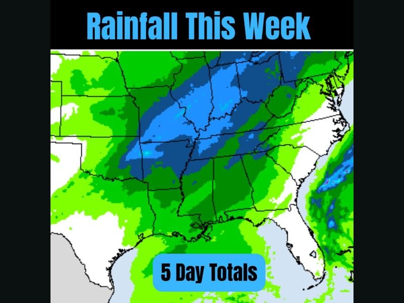
UNITED STATES – Forecast rainfall data through Friday shows a developing frontal system bringing widespread rain across the central and Midwest states, while much of the East Coast and large parts of Florida remain relatively dry, according to the latest five-day rainfall projections. The pattern highlights a growing contrast between a wetter middle of the country and drier conditions farther east.
Heaviest Rainfall Focused Over the Central and Midwest States
The rainfall map shows higher five-day totals stretching from parts of the Plains into the Midwest and Ohio Valley, including areas that appear to cover Missouri, Illinois, Indiana, Kentucky, and surrounding states. These regions are positioned under a frontal boundary expected to become more active toward the end of the week.
Forecast guidance suggests this system could bring multiple rounds of rain rather than a single quick event, increasing total accumulations over several days.
Frontal Line Signals Storm Potential Late in the Week
Meteorological signals point to a frontal line brewing over the central U.S., which may help organize showers and storms as the week progresses. While exact timing and intensity are still evolving, the setup is one worth monitoring heading toward the late-week period. Some of the moisture associated with this system is expected to shift eastward into the weekend, though the highest totals currently remain focused farther west.
East Coast and Florida Largely Miss Out on Rain
In contrast, the data shows much of the East Coast staying comparatively dry through Friday, with only lighter or more scattered rainfall indicated. Large portions of Florida also appear to remain dry, missing the core of the central U.S. storm track. This uneven distribution highlights a pattern where rainfall is not evenly spread across the country, favoring the middle states instead.
What to Watch Next
As the week continues, forecasters will be watching how the central U.S. frontal system evolves and how much of its moisture ultimately slides east into the weekend. Any shift in the storm track could adjust rainfall totals, particularly for Midwest states currently in the wetter zone. NapervilleLocal.com will continue tracking this pattern and provide updates as confidence increases on timing and regional impacts.

I’ve lived in Naperville long enough to see how quickly our community changes — from new developments downtown to sudden shifts in our Midwest weather. Reporting on Naperville news and daily forecasts gives me the chance to keep neighbors informed about what really matters. My goal is simple: deliver clear, timely updates so you always know what’s happening in our city and what to expect from the skies above.