
Significant Tornadoes and All-Hazards Severe Threat Targeting the Dakotas and Western Minnesota Including Fargo Sioux Falls and Rapid City Tuesday June 9th
DAKOTAS AND WESTERN MINNESOTA — An all-hazards severe weather threat is on deck for Tuesday June 9th across the Dakotas and western Minnesota, with a powerful shortwave tracking through the northern continental United States responsible for a heightened and significant severe weather setup.
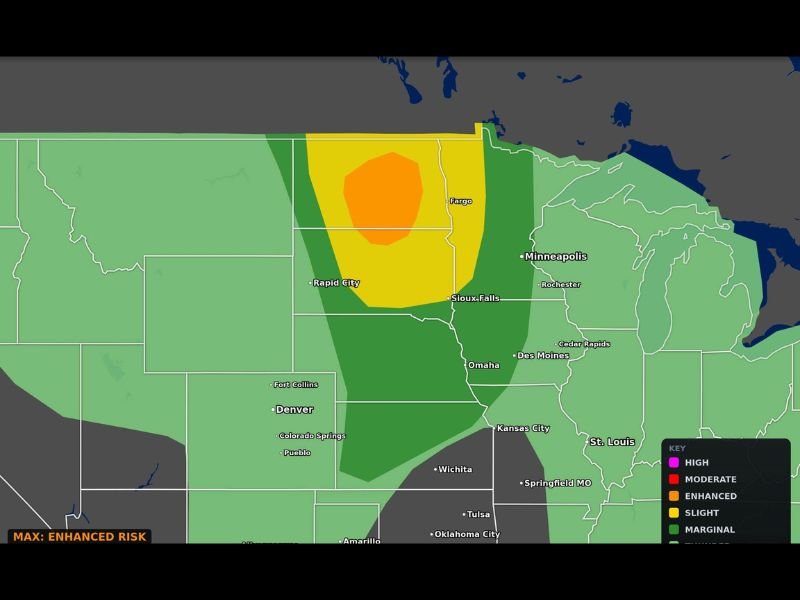
The Max Velocity categorical outlook updated Sunday June 7th places an Enhanced Risk orange zone centered over the North Dakota and South Dakota border region near Fargo, surrounded by a Slight Risk yellow zone extending from Rapid City through Sioux Falls and toward Minneapolis.
Enhanced Risk Orange Zone Centered Near Fargo and the Dakota Border Region
The Enhanced Risk zone represents the third highest tier on the five-level severe weather scale and is centered over the North Dakota and South Dakota border area near Fargo. This level of risk indicates well-organized and long-tracked severe storms are likely, with all hazards including tornadoes, very large hail, and damaging winds all in play across the Enhanced zone.
Communities across the Fargo corridor and surrounding areas in both Dakotas should treat Tuesday as a serious severe weather day with shelter plans in place well before storm initiation.
Slight Risk Yellow Zone Covers Rapid City Sioux Falls and Toward Minneapolis
The broader Slight Risk yellow zone extends from Rapid City and western South Dakota northeastward through Sioux Falls and continuing toward the Minneapolis and Rochester corridor in western Minnesota. This zone carries a meaningful severe weather threat and communities within it should not dismiss the risk simply because they sit outside the Enhanced zone core.
A powerful shortwave tracking through the region is the primary atmospheric driver elevating this setup beyond typical summer storm activity.
Additional Severe Weather Possible in the Missouri Valley and Midwest Later This Week
Beyond Tuesday’s northern plains threat, forecasters are monitoring the potential for additional severe weather areas to evolve across the Missouri Valley and broader Midwest through the coming days. Confidence at that extended range remains low but the overall pattern supports a continued active severe weather stretch across the central United States through the week. Stay with NapervilleLocal.com for the latest weather updates and local forecast coverage.

I’ve lived in Naperville long enough to see how quickly our community changes — from new developments downtown to sudden shifts in our Midwest weather. Reporting on Naperville news and daily forecasts gives me the chance to keep neighbors informed about what really matters. My goal is simple: deliver clear, timely updates so you always know what’s happening in our city and what to expect from the skies above.