
Indiana Set for Dramatic Temperature Crash From Near 60°F Friday Morning to Single-Digit Wind Chills by Early Sunday, Forecast Shows
United States — New forecast data highlights a major temperature swing across Indiana, where unusually warm air in the upper 50s and low 60s Friday morning will be followed by a dramatic plunge into the 20s by Sunday morning. Wind chills across a large portion of the state may fall into the single digits, marking one of the sharpest short-term temperature drops so far this season.
This type of rapid shift can create challenges for travel, early-morning activities, and weekend planning across the region, as mild conditions quickly give way to winter cold.
Warm Start Friday Before Intense Weekend Drop
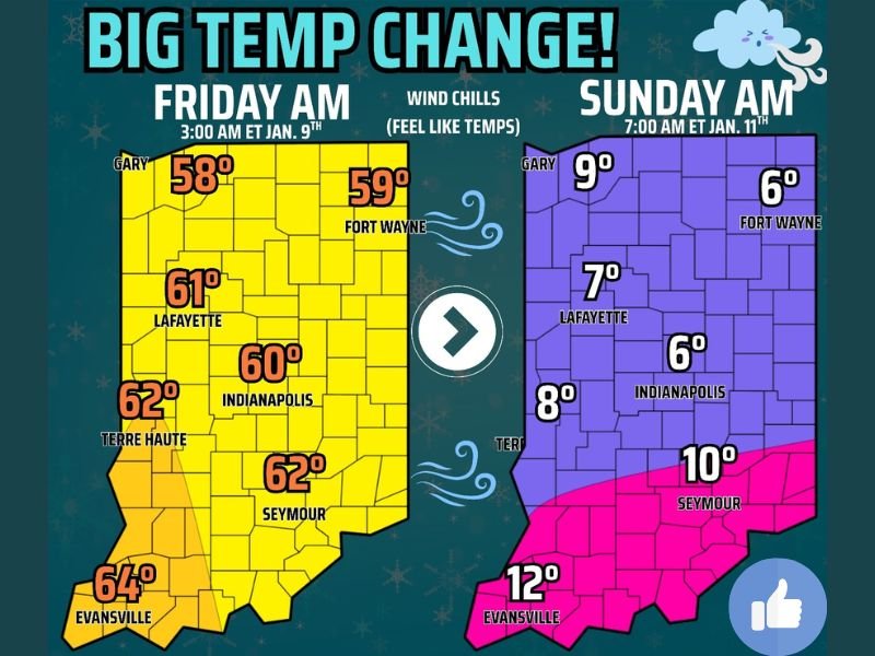
Forecast maps show warm air dominating much of Indiana early Friday, with morning “feel-like” temperatures showing:
- Evansville: 64°F
- Terre Haute: 62°F
- Indianapolis: 60°F
- Lafayette: 61°F
- Fort Wayne: 59°F
- Gary: 58°F
- Seymour: 62°F
These values resemble early spring more than mid-January, creating a short-lived warm burst across the state.
Arctic Air Arrives: Single-Digit Wind Chills by Sunday Morning
By early Sunday, a powerful cold front will have moved through the region, sending temperatures sharply downward. The wind chill map shows dramatically colder values across Indiana:
- Gary: 9°F
- Lafayette: 7°F
- Fort Wayne: 6°F
- Indianapolis: 6°F
- Seymour: 10°F
- Evansville: 12°F
The drop represents a 50–55 degree swing within 48 hours, a transition likely to feel abrupt after the unusually warm conditions preceding it.
Why This Temperature Crash Is Significant
This rapid decline is driven by:
- A strong Arctic air mass pushing south
- A cold front following a period of enhanced warmth
- Gusty winds accelerating the drop and lowering wind chills
Such steep changes can impact:
- Road travel conditions as temperatures fall below freezing
- Outdoor events scheduled for Friday evening and Saturday
- Health risks for those exposed to cold early Sunday
- Heating demand across residential and commercial areas
Residents may feel as if the warm air is “pulled away like a rug,” as noted in the original forecast discussion.
What Indiana Residents Should Prepare For
While no precipitation type is indicated in the provided maps, the temperature crash alone requires planning:
- Layer clothing for cold morning wind chills Sunday
- Prepare for slick spots where moisture remains on roads
- Ensure outdoor pets and livestock have cold protection
- Adjust weekend plans based on the rapid shift
The sudden nature of the change may catch some residents off guard, especially those expecting the warmth to linger.
Looking Ahead
While this temperature swing does not impact Illinois directly based on current data, it remains a notable regional weather shift that reflects broader January pattern volatility across the central United States. NapervilleLocal.com will continue monitoring national weather developments and providing accurate, data-based reporting as conditions evolve.

I’ve lived in Naperville long enough to see how quickly our community changes — from new developments downtown to sudden shifts in our Midwest weather. Reporting on Naperville news and daily forecasts gives me the chance to keep neighbors informed about what really matters. My goal is simple: deliver clear, timely updates so you always know what’s happening in our city and what to expect from the skies above.