
Winter Storm Signals Strengthen Across the Central and Eastern United States as Mid-January Pattern Flip Points Toward Increased Cold and Snow Potential
United States — New long-range guidance shows increasingly strong winter signals across a wide portion of the central and eastern United States, suggesting that after the midpoint of January, the weather pattern may shift decisively toward colder air, more frequent storm systems, and improved snow potential.
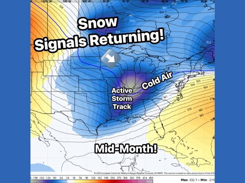
This emerging setup does not identify specific cities or states yet, but the map highlights a large region under a deepening trough, an active storm track, and a growing corridor of winter-friendly cold air.
Why Meteorologists Are Watching the Mid-January Window
Meteorological indicators are aligning in a way that often leads to more winter activity, including:
- A strengthening dip in the jet stream
- Colder air pressing south from Canada
- Increased energy tracking across the central U.S.
- A storm path favorable for repeated systems
Although no individual storm can be identified at this stage, the overall pattern becoming dominant is what forecasters pay attention to in long-range winter outlooks.
Stronger Storm Track Taking Shape
The map shows a pronounced area of blues and purples across the central United States, representing:
- A more active storm track
- Deeper upper-level support for storm development
- Repeated opportunities for snow or mixed precipitation
- More organized winter systems than earlier in the month
This shift suggests that the previously quiet start to January may not continue into the latter half of the month.
Colder Air Expanding Southward
Alongside the storm track, colder air is expected to expand into a broad region, creating a setup more suitable for wintry conditions. This includes:
- Lower daytime temperatures
- Higher likelihood of snowfall in colder pockets
- Increased overnight chill
- Potential for multiple systems to produce winter impacts
Again, the map does not specify exact locations, but it emphasizes a large-scale pattern, not isolated local effects.
No Locked-In Storms Yet, but Confidence in the Trend Is Rising
Forecasters caution that the details — timing, precipitation type, snowfall amounts, and precise locations — will depend on short-range model updates. For now:
- The pattern is still evolving
- Exact storm paths are not defined
- Local impacts cannot be pinpointed
However, the signal for a colder and more active winter period is strong.
What This Means for the Central and Eastern U.S.
Residents across the highlighted zone should be prepared for:
- A transition to colder temperatures
- More frequent system tracking
- Possible winter storms during the mid- to late-January period
- Increased weather variability
This is the type of pattern where active systems can develop quickly once the cold air is firmly in place.
Looking Ahead
As the mid-month period approaches, new data will clarify whether significant snow events develop, where storm tracks align, and how cold the air becomes. At this stage, the emphasis is on the strengthening trend, not exact outcomes.
NapervilleLocal.com will continue monitoring this evolving national pattern and provide clear, accurate updates as the signal comes into sharper focus.

I’ve lived in Naperville long enough to see how quickly our community changes — from new developments downtown to sudden shifts in our Midwest weather. Reporting on Naperville news and daily forecasts gives me the chance to keep neighbors informed about what really matters. My goal is simple: deliver clear, timely updates so you always know what’s happening in our city and what to expect from the skies above.