
Alabama Sees Rain Today as Cold Front Moves Through, Brief Flurries Possible Tonight With Colder, Drier Pattern Ahead
Alabama — A cold front pushing through the Deep South is bringing a round of rain across much of Alabama today, followed by a noticeable drop in temperatures tonight as colder air settles in behind the system. Radar data shows widespread rain across the southern half of the state this morning, with additional showers developing farther north as the front advances. Forecasters say rainfall amounts will generally be light, but the change in air mass will set the stage for much cooler conditions statewide through the weekend.
Rain Moves Across the State Ahead of the Front
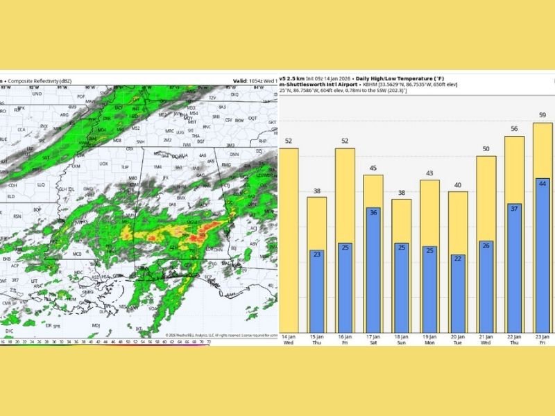
Radar imagery shows a large area of rain covering southern Alabama, while scattered showers extend northward along the advancing cold front into Tennessee. As the front continues southward, periods of rain are expected at times across Alabama today, though most locations should receive a quarter inch of rain or less. Despite the rain, temperatures will remain relatively mild ahead of the front, with highs reaching the low to mid-50s across much of the state.
Cold Air Arrives Tonight, Flurries Possible in North Alabama
As colder air rushes in behind the front tonight, a few scattered light snow flurries may develop over North Alabama. Forecasters stress that no accumulation or travel impacts are expected, and any flurries would be brief and spotty. The primary story overnight will be the temperature drop, as colder, drier air spreads southward across the region.
Thursday Turns Sunny but Breezy and Cold
By Thursday, skies will clear across Alabama, but conditions will remain breezy and noticeably colder. High temperatures are expected to range from the mid-30s across the Tennessee Valley to the low 40s in southern counties. The combination of sunshine and wind will make the air feel colder, especially during the morning and early afternoon.
Another Front Friday, Then a Chilly Weekend
Clouds will increase again on Friday as another cold front approaches, bringing a chance of light rain Friday night. Temperatures will briefly rebound into the 50s Friday afternoon before cooler air returns behind the front.
Looking ahead to the weekend:
- Saturday highs: mainly in the 40s
- Sunday highs: generally between 35 and 45 degrees
The weekend is expected to be mostly dry, though a weak disturbance along the front near the northern Gulf Coast could bring a few sprinkles or flurries to South Alabama Saturday night, with no accumulation expected.
Cold Start to Next Week, Gradual Warm-Up Later
The first half of next week will feature a cold and dry pattern, with morning lows mostly in the 20s and daytime highs in the 30s and 40s. A warming trend is expected to develop later in the week, with many communities climbing back into the low 60s by Friday. Long-range guidance suggests rain chances may return late next week, though details remain uncertain.
Why This Matters Beyond Alabama
This setup highlights how winter cold fronts continue to sweep through the southern United States, bringing sharp temperature changes even when snowfall impacts remain minimal. For Midwest readers, it offers context on how the same large-scale weather patterns affect regions differently.
NapervilleLocal.com will continue providing accurate, location-verified national weather updates, with clear explanations when systems impact large portions of the country.

I’ve lived in Naperville long enough to see how quickly our community changes — from new developments downtown to sudden shifts in our Midwest weather. Reporting on Naperville news and daily forecasts gives me the chance to keep neighbors informed about what really matters. My goal is simple: deliver clear, timely updates so you always know what’s happening in our city and what to expect from the skies above.