
Cold Front Crashes the Deep South as NWS Flags Rare Sunday Morning Snowflake Risk for Georgia and Florida Panhandle
FLORIDA & GEORGIA — A sharp cold front sweeping south overnight is setting the stage for a rare early-morning wintry setup across parts of South Georgia and the Florida Panhandle on Sunday, according to the latest National Weather Service update from Tallahassee.
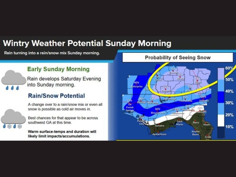
While this is not a guaranteed snow event, forecasters say conditions behind the front may briefly support rain changing to a rain-snow mix — or even all snow — in a narrow window around sunrise.
What the National Weather Service Is Watching Closely
The NWS indicates rain will develop Saturday evening and continue into Sunday morning, with colder air rapidly filtering in behind the front. As that colder air arrives, precipitation may transition to a wintry mix.
The highest probability for seeing snowflakes currently stretches across South Georgia, where probabilities range from roughly 40 to 55 percent. Parts of the Florida Panhandle remain a “decent maybe,” though confidence is lower farther south.
Snow Accumulation Looks Limited — But Not Impossible
Even where snowflakes do appear, impacts are expected to be minimal. Forecast guidance suggests that if snow manages to accumulate at all, totals would be a trace to around one inch, mainly on grassy or elevated surfaces.
Warm ground temperatures and marginal surface readings will make road accumulation unlikely, limiting travel concerns.
Why This Setup Still Matters
While snow in this region is rare, forecasters stress that pattern recognition is important, especially with a strong cold front and sufficient moisture in place. Even brief snow in the Deep South requires close monitoring due to its unusual nature. This setup highlights how small temperature changes overnight can determine whether rain stays rain or flips briefly to snow, especially near daybreak.
Bottom Line
A fast-moving cold front could bring a brief, low-impact wintry surprise to parts of South Georgia and possibly the Florida Panhandle early Sunday, with snowflakes more likely than meaningful accumulation. Confidence remains moderate, and small shifts in temperature will make all the difference. For continued updates, regional winter pattern tracking, and clear breakdowns of evolving forecasts, stay connected with NapervilleLocal.com and check back as conditions develop.

I’ve lived in Naperville long enough to see how quickly our community changes — from new developments downtown to sudden shifts in our Midwest weather. Reporting on Naperville news and daily forecasts gives me the chance to keep neighbors informed about what really matters. My goal is simple: deliver clear, timely updates so you always know what’s happening in our city and what to expect from the skies above.