
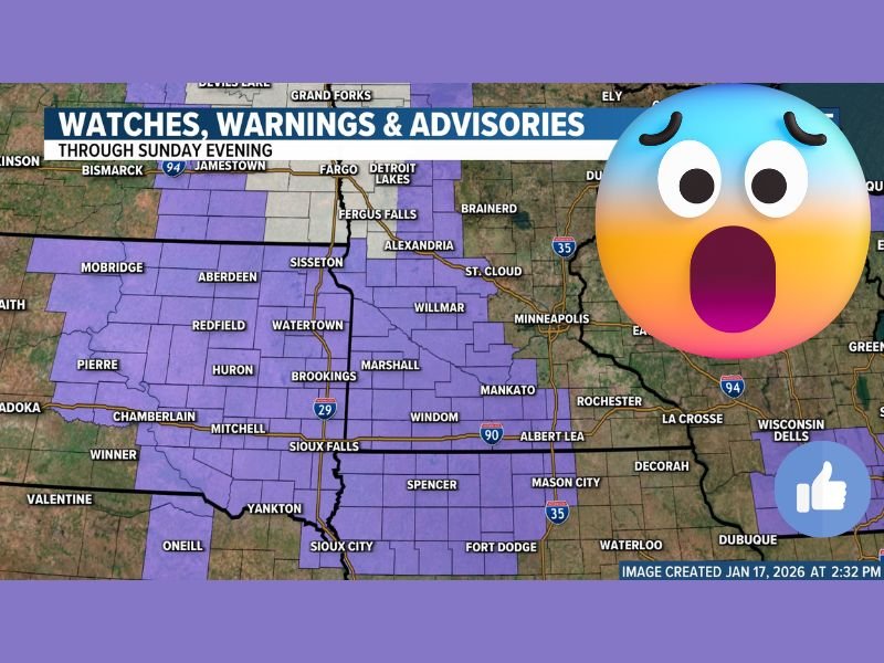
Eastern South Dakota and Minnesota Face Dangerous Visibility Swings as Light Snow Combines With 60 MPH Wind Gusts Under Active Advisory
SOUTH DAKOTA & MINNESOTA — A Winter Weather Advisory is now in effect from late Saturday night through Sunday evening, covering a wide stretch of eastern South Dakota into central and southern Minnesota, where light snowfall paired with powerful wind gusts of 40 to 60 mph could create rapidly changing and locally hazardous travel conditions.
While snow totals will remain modest, meteorologists are warning that visibility — not accumulation — will be the primary concern as bursts of snow and wind interact throughout the day Sunday.
Light Snow Totals, But Localized Higher Pockets Possible
Forecast guidance continues to show:
- Around 1 inch or less of snow for most locations
- Isolated pockets up to 2 inches possible in parts of far eastern Minnesota
These totals are similar to what the region has experienced over the past few days, but the impact profile remains elevated due to wind intensity.
Strong Winds Could Push Conditions Toward Blizzard-Like Visibility
The biggest threat with this system is wind-driven snow, not accumulation.
As bursts of snow move through:
- Visibility could drop sharply in a matter of minutes
- Conditions may briefly approach blizzard criteria, especially while snow is actively falling
- Visibility may vary dramatically over very short distances
Meteorologists stress that drivers could go from clear conditions to near-whiteout with little warning, even though snowfall rates remain light.
Travel Conditions May Change Rapidly Through Sunday
The advisory period runs late Saturday night through Sunday evening, with the most volatile conditions expected during:
- Periods of active snow bursts
- Times of peak wind gusts
Officials strongly recommend:
- Monitoring state 511 road condition systems
- Checking DOT traffic cameras for real-time visibility
- Avoiding unnecessary travel during active snow and wind bursts
Even well-treated roads may become hazardous when visibility collapses suddenly.
Forecast Pattern Matches Recent Days, But Impacts Remain Elevated
Meteorologists note this setup is very similar to recent events, where snow amounts stayed low but travel impacts were still significant due to wind-driven reductions in visibility.
The pattern reinforces that accumulation alone does not define winter weather risk, especially in open and rural areas across the Plains and Upper Midwest.
Bottom Line: Watch Visibility Closely, Not Snow Totals
This is not a major snowstorm, but it is a high-impact visibility event for parts of South Dakota and Minnesota. If you must travel, expect conditions to change quickly and without warning, especially during snow bursts combined with strong wind gusts.
For continued winter weather updates, regional advisories, and real-time travel impacts, stay connected with NapervilleLocal.com and share what you’re seeing on the roads in your area.

I’ve lived in Naperville long enough to see how quickly our community changes — from new developments downtown to sudden shifts in our Midwest weather. Reporting on Naperville news and daily forecasts gives me the chance to keep neighbors informed about what really matters. My goal is simple: deliver clear, timely updates so you always know what’s happening in our city and what to expect from the skies above.