
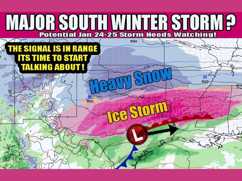
Growing Signals Point to a Potential Major Winter Storm Across Oklahoma, Texas, and Arkansas Around January 24–25
UNITED STATES — Long-range weather models are beginning to show increasing agreement on a potentially impactful winter storm developing across parts of Oklahoma, Texas, and Arkansas next weekend, centered around Saturday, January 24, according to the latest global guidance.
Both the GFS and European (EURO) models are now consistently producing a storm signal strong enough to warrant early discussion, especially given that this system is now less than seven days away, a timeframe where meaningful forecast trends start to matter.
Model Agreement Is Improving, Raising Confidence in a Wintry Setup
Meteorologists note that while this system is still outside the short-range forecast window, the overall signal for a winter storm is strengthening, not weakening.
At this stage:
- Models suggest heavy snow potential on the cold side of the system
- A significant ice threat may develop farther south, especially where warm air overrides shallow surface cold air
- The setup spans Oklahoma, north and central Texas, and much of Arkansas
This region has largely avoided major winter weather so far this season, which increases the potential impact should this storm verify.
Heavy Snow and Ice Are Both on the Table
Based on current model depictions:
- Heavy snow bands could develop north of the storm track
- Ice accumulation is possible closer to the transition zone between cold and warm air
- The storm structure suggests a classic southern Plains winter setup, where small track shifts could dramatically change local impacts
Meteorologists stress that specific snowfall or ice totals cannot yet be determined, but the pattern supports the possibility of disruptive winter weather, not just a minor event.
Timing and Exact Impacts Remain Uncertain
Despite growing confidence in the overall pattern, important details remain unresolved:
- Exact storm track
- Precipitation type by location
- Onset and duration of impacts
At this range, forecasters caution against locking onto any single model run. However, the consistency across multiple major models is what makes this signal noteworthy.
As forecasters often say: If it happens, you’re prepared. If it fades, that’s part of the process.
Why This Setup Deserves Close Monitoring
This developing pattern arrives during a climatologically favorable window for winter storms in the southern Plains, increasing the odds that cold air will be in place when moisture arrives.
Even modest changes in the storm’s evolution could result in:
- Major travel disruptions
- Power outages in ice-prone areas
- Significant forecast upgrades later this week
What Happens Next
Confidence will increase rapidly over the next few days as:
- Higher-resolution models come into range
- Temperature profiles become clearer
- Forecast offices begin refining precipitation type zones
For now, this is firmly in the “watch closely” phase, but it is no longer just speculative noise.
Continue following updates and detailed breakdowns on NapervilleLocal.com, where we track developing weather patterns nationwide and explain what they could mean as confidence improves.

I’ve lived in Naperville long enough to see how quickly our community changes — from new developments downtown to sudden shifts in our Midwest weather. Reporting on Naperville news and daily forecasts gives me the chance to keep neighbors informed about what really matters. My goal is simple: deliver clear, timely updates so you always know what’s happening in our city and what to expect from the skies above.