
January 24 Winter Storm Could Bring Snow, Ice, or Cold Rain Across the Ohio Valley, Tennessee Valley, and Southeast as Track Remains Highly Uncertain
Tennessee – A developing storm system is being closely monitored as it moves out of the central United States later next week, with the potential to impact parts of the Ohio Valley, Tennessee Valley, and the Southeast around January 24. Meteorologists are emphasizing that this setup is unusually complex, with small shifts in the storm’s path capable of dramatically changing impacts from one location to another.
At this stage, the system remains several days away, but model guidance shows enough consistency to warrant early attention. The key challenge lies in the exact track of the low-pressure center, which is still unresolved.
Why Meteorologists Are Calling This a “Very Tricky” Winter Setup
This system has been labeled a “very tricky situation” because winter weather outcomes will depend on a delicate balance between cold air already in place and warmer air pushing northward as the storm develops.
In winter systems like this, even a 50 to 100 mile shift in the storm track can mean the difference between:
- Heavy snow
- A disruptive ice storm
- Cold, soaking rain with little winter impact
Because of this sensitivity, confidence in specific outcomes remains low, even though the overall storm signal is increasing.
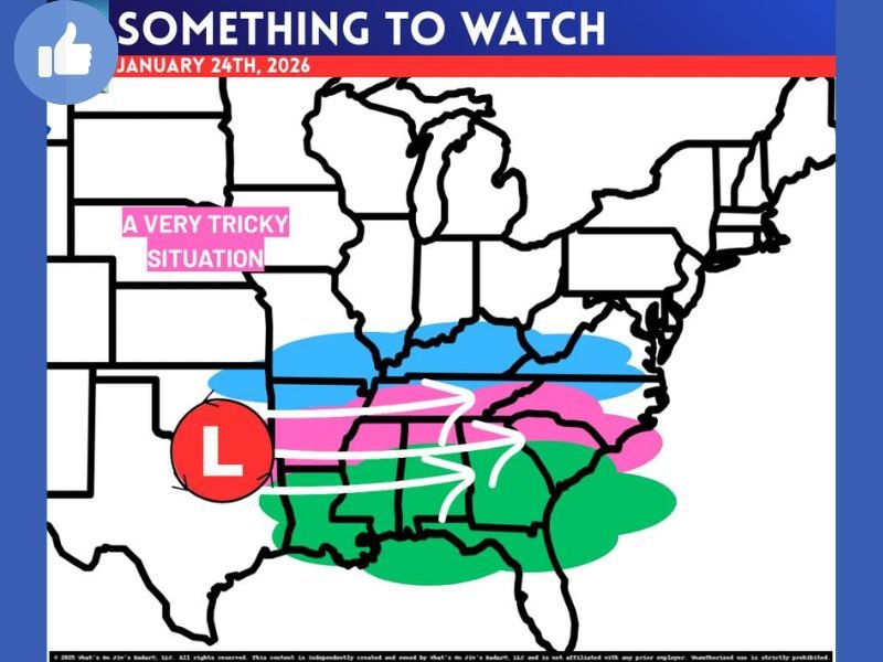
What the Different Impact Zones Represent
Meteorologists often use color-coded zones to represent possible outcomes rather than fixed forecasts:
- Green zone indicates warmer air dominating, leading to mostly rain
- Pink zone represents a wintry mix area, where sleet, freezing rain, and occasional snow can overlap
- Blue zone marks colder air regions where precipitation would fall primarily as snow
The pink wintry-mix zone is typically the most dangerous, as freezing rain and sleet can create hazardous travel conditions even with relatively light precipitation.
A Battle Between Cold Air and Advancing Warmth
The entire event will be determined by a classic winter weather battle:
- Cold air entrenched at the surface
- Versus warmer air attempting to surge north above it
Model guidance is still struggling with critical factors such as how fast warm air advances, how stubborn surface cold air remains, and where the low-pressure center ultimately tracks.
Until those details become clearer, forecast confidence for any one location remains limited.
What Residents Should Do Right Now
With uncertainty still high, this is not yet a time for panic, but it is a time for awareness. Residents across the Ohio Valley, Tennessee Valley, and Southeast should continue monitoring forecasts through the coming days, especially as confidence improves closer to the event.
Those with travel plans late next week should remain flexible, as forecast changes are likely as new data becomes available.
The Bottom Line
This potential winter storm has the ingredients to produce very different outcomes across short distances, and confidence will remain limited until the storm track becomes clearer. Expect forecast updates to evolve frequently as meteorologists refine timing, precipitation type, and impact zones.
For continued weather updates, forecast breakdowns, and regional winter weather coverage, stay connected with NapervilleLocal.com, and share how winter weather uncertainty affects your plans in the comments.

I’ve lived in Naperville long enough to see how quickly our community changes — from new developments downtown to sudden shifts in our Midwest weather. Reporting on Naperville news and daily forecasts gives me the chance to keep neighbors informed about what really matters. My goal is simple: deliver clear, timely updates so you always know what’s happening in our city and what to expect from the skies above.