
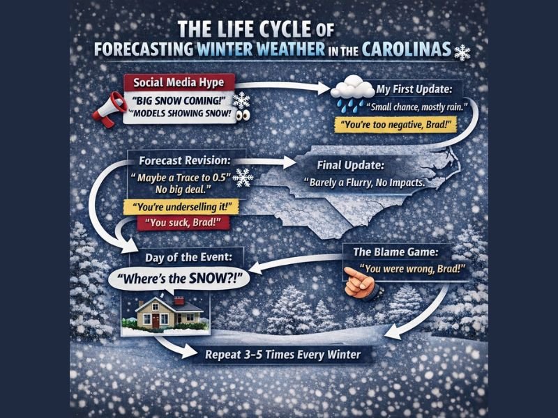
North Carolina and South Carolina Winter Forecast Cycle Explained: Why Social Media Snow Hype Rarely Matches Reality
NORTH CAROLINA AND SOUTH CAROLINA — Each winter season across the Carolinas tends to follow a predictable and often frustrating pattern when it comes to snow forecasts. A mix of early model speculation, viral social media posts, and the region’s marginal winter climate frequently creates expectations that simply don’t match what ultimately falls. The latest forecast discussion circulating online once again highlights why winter weather in the Carolinas is so difficult to pin down — and why disappointment often follows.
Early Model Runs Spark Snow Hype Across the Carolinas
The cycle usually starts several days out when early computer models hint at cold air interacting with an approaching system. Across North Carolina and South Carolina, those initial signals often trigger bold online claims of “big snow” or a “major winter storm”, even though confidence is still very low.
At this stage, most guidance does not support a high-impact winter event. However, single-frame model screenshots spread rapidly, pushing expectations higher long before the forecast becomes reliable.
Professional Forecasts Emphasize Low-End Snow Potential
As more data arrives, meteorologists typically bring the forecast back to reality. In the Carolinas, that usually means rain remains the dominant precipitation type, with snow chances staying small but not zero.
Cold air near the surface is often shallow and fragile, making it easy for warm air aloft to change snow to rain. Forecasts at this point usually highlight rain with occasional snow mixing in, rather than a true snowstorm.
Forecast Refinements Narrow Accumulation Expectations
As the event gets closer, snow projections are often trimmed further. What once looked dramatic online usually becomes a forecast for a trace to around half an inch, with localized higher amounts possible only under narrow conditions.
For most of North Carolina and South Carolina, any accumulation is typically:
- Brief
- Light
- Limited to grassy or elevated surfaces
- Low impact for travel
Event Day Reality: Flakes, Brief Bursts, or Nothing at All
When the day arrives, reality sets in. Many areas see a few flakes mixing in, a quick snow burst, or simply cold rain. This is often when frustration peaks — even though the forecast verified exactly as expected.
The familiar question returns across the Carolinas: “Where’s the snow?” What’s often missed is that significant snow was never the most likely outcome, despite early speculation.
Why Small Track Changes Matter So Much in the Carolinas
Winter storms in North Carolina and South Carolina are extremely sensitive to storm track. A shift of just 50 to 100 miles can mean the difference between:
- Snow
- Sleet or freezing rain
- Cold rain
Forecast models frequently struggle with:
- The exact low-pressure path
- How fast warm air moves north
- How stubborn surface cold air remains
These variables make Carolinas winter forecasting far more complex than in colder regions.
Winter Forecasting in North Carolina and South Carolina
This cycle repeats three to five times every winter. The key takeaway is that forecasts are based on what is most likely, not what is most exciting.
In the Carolinas, the most likely outcome is often cold rain with limited snow potential, even when early model signals briefly suggest otherwise. Understanding this helps set realistic expectations — and avoids unnecessary panic — when winter weather enters the forecast.
Have thoughts on winter forecasting in the Carolinas or experienced this cycle yourself? Share your perspective and stay updated with local weather coverage on NapervilleLocal.com.

I’ve lived in Naperville long enough to see how quickly our community changes — from new developments downtown to sudden shifts in our Midwest weather. Reporting on Naperville news and daily forecasts gives me the chance to keep neighbors informed about what really matters. My goal is simple: deliver clear, timely updates so you always know what’s happening in our city and what to expect from the skies above.