
Alabama, Tennessee, and Mississippi Could Face High-Impact Ice Storm Threat as Freezing Rain Signals Grow More Concerning
ALABAMA, TENNESSEE, AND MISSISSIPPI — Forecasters are closely monitoring a potential freezing rain and ice storm setup that could impact parts of the Tennessee Valley and surrounding areas, with ice accumulation becoming the primary concern rather than snow. While the final outcome is still uncertain, meteorologists stress that even small increases in ice amounts can dramatically increase damage and power outage risks.
This system is still several days out, but preparation messaging is being emphasized early due to the high-impact nature of ice storms, which often escalate quickly once freezing rain begins.
What Triggers an Ice Storm Warning
According to National Weather Service guidance used by the Huntsville office, an Ice Storm Warning is typically issued when freezing rain is expected to produce ice accumulations of ¼ inch or greater. These warnings are generally issued around 48 hours before the event, once confidence increases that freezing rain will be the dominant precipitation type. The danger rises sharply as ice amounts increase, especially when winds strengthen, adding stress to trees and power lines already coated in ice.
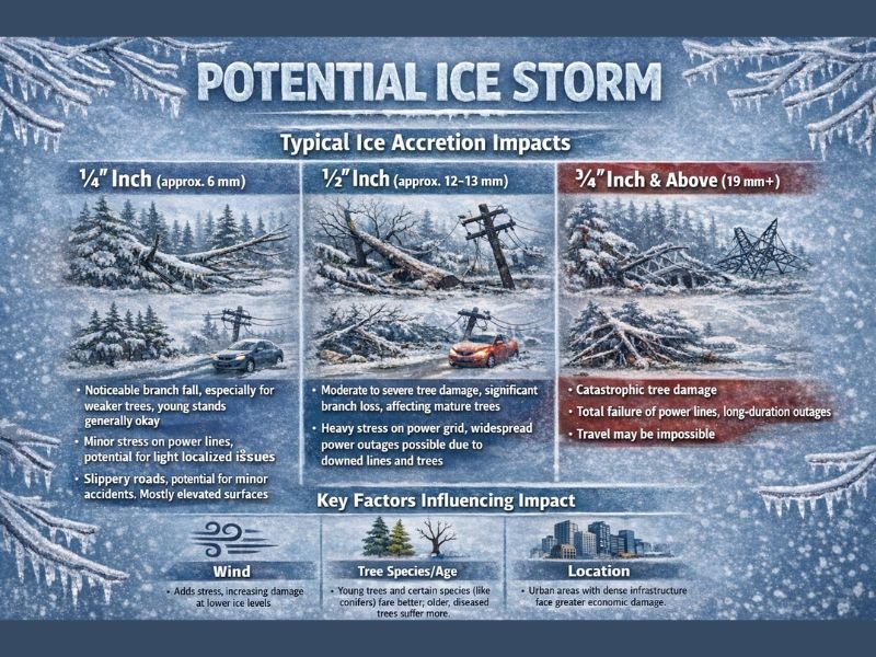
How Ice Accumulation Levels Translate to Real-World Impacts
Ice storms are not all the same, and impacts scale rapidly with accumulation amounts.
At ¼ inch of ice, impacts often include noticeable branch breakage, slick elevated roadways, and minor localized power issues, especially on bridges and overpasses.
At ½ inch of ice, impacts become far more serious. Moderate to severe tree damage is common, large branches snap, and widespread power outages become possible as power lines experience heavy stress from ice weight.
At ¾ inch or more, conditions can turn catastrophic. Entire trees may collapse, power infrastructure can fail for extended periods, and travel may become impossible due to downed trees, power lines, and untreated ice-covered roads.
Key Factors That Can Worsen Ice Storm Damage
Several variables determine whether an ice event remains manageable or becomes destructive. Wind speed plays a major role, as even moderate gusts dramatically increase strain on ice-coated trees and power lines.
Tree species and age also matter. Younger trees and some species handle ice better, while older, diseased, or brittle trees are far more likely to fail.
Location and infrastructure density influence outcomes as well. Urban areas with dense power networks face higher outage risks and greater economic disruption when ice accumulation increases.
Why Forecast Uncertainty Remains High
At this stage, meteorologists emphasize that the best-case scenario is still heavy cold rain, which would significantly limit impacts. However, the presence of cold air near the surface means a narrow temperature difference could shift rain to freezing rain, rapidly escalating conditions.
This type of setup requires fine-tuning in the days ahead, and forecasters urge residents not to focus on exact ice totals yet, but instead to understand the potential impact range.
Bottom Line: Prepare Early, Stay Flexible
Ice storms are among the most damaging winter weather events in the South, often producing long-lasting power outages and dangerous travel conditions with little warning once freezing rain begins.
Residents across Alabama, Tennessee, and Mississippi are encouraged to monitor forecast updates closely, prepare for possible power disruptions, and avoid unnecessary travel if freezing rain becomes more likely. For continued winter weather updates, preparedness guidance, and regional impact breakdowns, stay informed and follow coverage at NapervilleLocal.com.

I’ve lived in Naperville long enough to see how quickly our community changes — from new developments downtown to sudden shifts in our Midwest weather. Reporting on Naperville news and daily forecasts gives me the chance to keep neighbors informed about what really matters. My goal is simple: deliver clear, timely updates so you always know what’s happening in our city and what to expect from the skies above.