
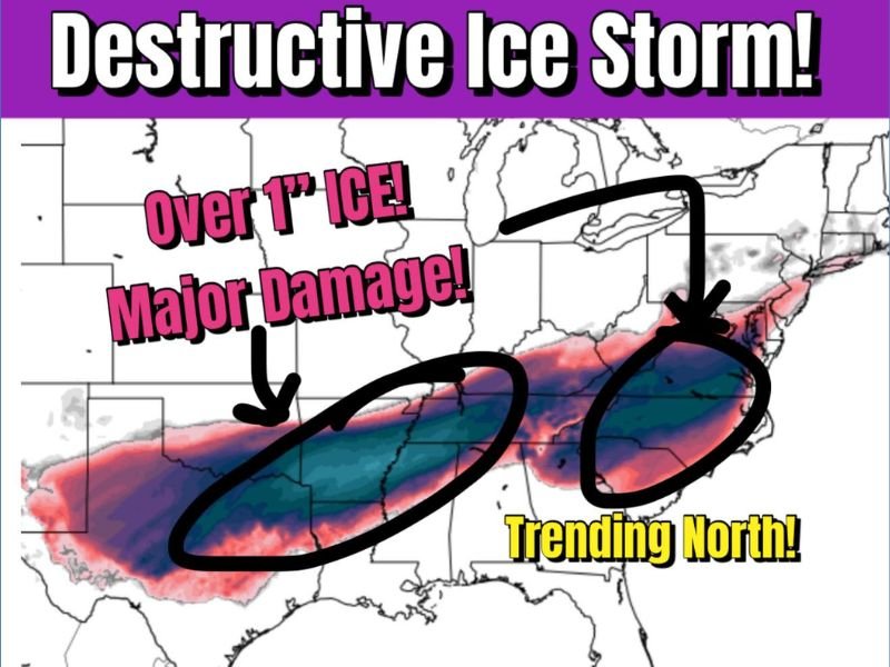
Destructive Ice Storm Signal Intensifies Across Texas, Arkansas, Tennessee, Kentucky, Virginia, and North Carolina as Track Trends North
UNITED STATES — Forecast confidence is increasing that a highly destructive ice storm may develop across a broad corridor of the central and eastern United States, with the latest European model guidance shifting the most dangerous icing threat farther north. While the exact placement of the heaviest ice remains uncertain, meteorologists agree that wherever the core of this system sets up, impacts could be severe and long-lasting.
Euro Model Shifts Ice Corridor North While Intensity Holds Steady
The newest European ensemble data indicates a northward adjustment in the storm track, expanding the threat zone from Texas and Arkansas through Tennessee, Kentucky, Virginia, and into North Carolina. Despite these shifts, the strength of the system has not weakened, which is raising serious concerns among forecasters.
Model projections show potential ice accretion exceeding one inch in parts of the impact zone, a threshold known to cause widespread tree damage, snapped power lines, and prolonged power outages. Even small deviations in track will not reduce the danger—only relocate it.
Why Ice Accumulation Over One Inch Is So Dangerous
Unlike snow, heavy ice accumulation places extreme stress on infrastructure and vegetation. Trees coated in thick ice become unstable, especially when combined with wind, and power lines are highly vulnerable under that load.
Key risks include:
- Large-scale tree failures
- Extended and widespread power outages
- Blocked roadways from falling debris
- Emergency access delays
These impacts can last days or even weeks, particularly in regions that experience extensive icing.
States Most At Risk Based on Current Guidance
While refinements are still ongoing, the most consistent signal for significant icing currently includes:
- Texas
- Arkansas
- Tennessee
- Kentucky
- Virginia
- North Carolina
The shaded corridor on the latest guidance shows a long, continuous band of freezing rain, indicating this will not be a localized event but rather a multi-state disruption.
Why Forecast Confidence Is Rising Despite Track Uncertainty
Forecasters are paying close attention not just to where the storm tracks, but to how consistently models are showing a major ice signal. The repeated appearance of destructive ice potential across multiple runs suggests this is not a fringe scenario.
Even if the axis shifts slightly north or south, the probability of a crippling ice storm somewhere within this corridor remains high.
What Comes Next
Meteorologists expect continued adjustments to snowfall and icing placement over the coming days, but residents across the highlighted states should begin early preparation. Once ice begins accumulating, conditions can deteriorate rapidly and recovery becomes difficult.
NapervilleLocal.com will continue monitoring this evolving winter storm and provide timely updates as new forecast data becomes available.

I’ve lived in Naperville long enough to see how quickly our community changes — from new developments downtown to sudden shifts in our Midwest weather. Reporting on Naperville news and daily forecasts gives me the chance to keep neighbors informed about what really matters. My goal is simple: deliver clear, timely updates so you always know what’s happening in our city and what to expect from the skies above.