
Prolonged Midwest Snow System to Move West-to-East From Northern Plains Saturday Night Into Mississippi River Valley by Monday
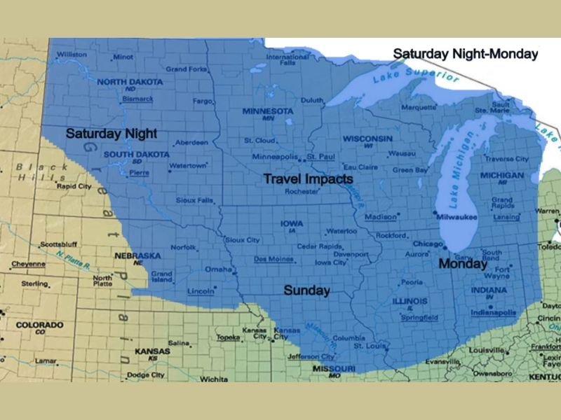
MIDWEST — Confidence is increasing that a prolonged winter weather system will affect large portions of the Midwest from Saturday night through Monday, bringing periods of snow and travel impacts as it moves steadily from west to east across the region.
Forecast guidance shows this system initially developing across the Northern Plains late Saturday night before shifting eastward through Minnesota and Iowa on Sunday. By Monday, the system is expected to reach areas along and east of the Mississippi River. While uncertainty remains regarding the axis of heavier snowfall totals, the overall progression and timing of the system are becoming clearer.
How the System Will Track Across the Region
The system is expected to begin impacting parts of the Northern Plains Saturday night, where travel impacts are forecast to peak first. As the system progresses east, snowfall and related travel concerns shift into Minnesota and Iowa on Sunday.
By Monday, the snow and associated impacts extend into the Mississippi River corridor and surrounding areas. This gradual west-to-east movement means different parts of the Midwest will experience impacts at different times rather than all at once.
Snowfall Expectations and Uncertainty
Meteorologists have not yet issued a finalized snowfall forecast due to lingering uncertainty over where the heaviest snow band will set up. While snow is increasingly likely across much of the affected region, exact totals may vary significantly depending on subtle changes in the storm’s track.
At this stage, snowfall is expected to be impactful enough to affect travel but not necessarily severe across all locations. Even lighter snowfall could still create slick road conditions, especially during overnight and early-morning hours.
Travel Impacts Through the Weekend
Travel impacts are expected at various points between Saturday night and Monday as the system progresses east. Impacts should peak Saturday night across the Northern Plains, shift into Minnesota and Iowa on Sunday, and reach areas near the Mississippi River by Monday.
Because the system is prolonged rather than fast-moving, road conditions may deteriorate gradually, making timing an important factor for travelers. Any changes in the system’s speed could shift when travel conditions are at their worst.
What to Watch Going Forward
Forecast confidence continues to increase that snow will occur somewhere across the Midwest, even as details on exact placement and totals are refined. Residents across the Northern Plains, Upper Midwest, and Mississippi River region should continue monitoring updates as the event approaches.
This system is expected to mark one of the final notable winter weather events of meteorological winter, reinforcing that winter travel risks are still present across the Midwest.
For continued updates on timing, snowfall placement, and regional travel impacts, stay with NapervilleLocal.com for the latest coverage.

I’ve lived in Naperville long enough to see how quickly our community changes — from new developments downtown to sudden shifts in our Midwest weather. Reporting on Naperville news and daily forecasts gives me the chance to keep neighbors informed about what really matters. My goal is simple: deliver clear, timely updates so you always know what’s happening in our city and what to expect from the skies above.