
Rare Florida “Flurry Forecast” Takes Shape as Models Hint at Snowflakes From Tampa Bay to the Nature Coast
Florida — A rare and unusual winter setup is drawing attention across the Sunshine State as meteorologists outline a low-confidence but notable chance of snow flurries late Saturday night into Sunday, an event informally dubbed a potential “Florida Flurry.”
While Florida is known for quickly shutting down snow hopes, forecasters say atmospheric conditions this weekend are just cold enough to allow flakes to briefly reach the ground in a few select areas, making this one of the better chances for flurries the state has seen in years.
Why Forecasting Florida Snow Is So Difficult
Meteorologists caution that this type of setup is notoriously hard to predict. Computer models struggle to resolve narrow bands of cold air and moisture at the same time, especially in Florida’s coastal environment.
Forecasters compare the situation to summertime pop-up storms, where one neighborhood gets rain while another stays sunny. In this case, everything will depend on real-time radar trends and short-term atmospheric changes as the event unfolds.
Where the Best Flurry Chances Exist
Based on current guidance, the best chances for seeing snowflakes appear to be closer to the Gulf Coast and north of Interstate 4, where temperatures may dip just low enough while moisture lingers.
The most favored areas include Pinellas County northward, locations west of Interstate 75, and parts of Florida’s Nature Coast. While brief flurries could technically occur almost anywhere within the viewing area, forecasters emphasize that the Nature Coast holds the highest odds.
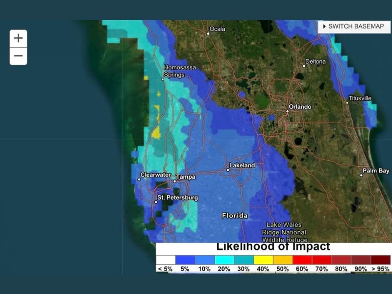
What the Impact Map Shows
A likelihood-of-impact map shows low but meaningful probabilities, generally in the 20 to 40 percent range, stretching along the west-central Florida coastline. This does not indicate accumulating snow, but rather the chance that flakes could briefly be observed.
Some models are slightly more aggressive than others, but confidence remains limited, reinforcing that this will be a short-lived and highly localized event if it occurs at all.
Timing: Late Saturday Night Into Sunday
Snow showers or flurries are most likely overnight Saturday night into early Sunday, when temperatures are coldest. Any flakes that do fall would likely be brief and spotty, with no meaningful accumulation expected.
Forecasters say anyone hoping to catch snowflakes will need to react quickly, monitor radar closely, and follow real-time updates as conditions evolve.
A Rare Opportunity for Florida Weather Watchers
While odds remain modest, forecasters note this may be the best chance Florida has had to see snowflakes in a long time. Even a brief flurry would be notable for a state where winter precipitation almost always falls as rain.
Weather watchers are encouraged to temper expectations but stay alert, as these rare setups can sometimes surprise even seasoned meteorologists.
As this unusual winter scenario approaches, NapervilleLocal.com will continue monitoring significant weather events across the country, including rare cold-weather setups that capture national attention.

I’ve lived in Naperville long enough to see how quickly our community changes — from new developments downtown to sudden shifts in our Midwest weather. Reporting on Naperville news and daily forecasts gives me the chance to keep neighbors informed about what really matters. My goal is simple: deliver clear, timely updates so you always know what’s happening in our city and what to expect from the skies above.