
Friday Clipper System Brings Next Snow Chance to Illinois and the Midwest With Gusty Winds and Blowing Snow Concerns
Illinois and the Midwest — Forecasters are flagging Friday, February 6 as the next meaningful opportunity for accumulating snow across northern Illinois and parts of the Midwest, as a strengthened clipper system tracks through the region late in the day and into the evening.
Early projections suggest snowfall totals of one to two inches are possible, though meteorologists stress it is still too early to lock in exact amounts. The bigger concern may be strong westerly winds, which could significantly reduce visibility and create areas of blowing and drifting snow.
Clipper System Targets Illinois Friday Evening
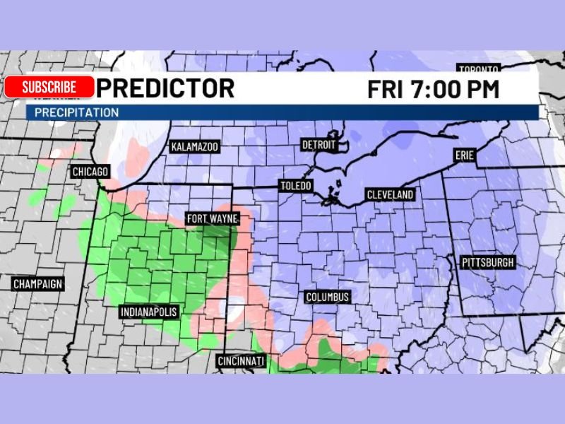
Forecast guidance shows a compact but energized clipper system moving southeast Friday afternoon and evening. Snow is expected to spread across Illinois, including areas near Chicago, before expanding into Indiana, Ohio, and southern Michigan during the evening hours.
The current timing places snow in the region around Friday evening, with the potential for a brief but impactful burst during the evening commute.
Snow Amounts Still Uncertain but Accumulation Likely
While the system does not appear to be a major snow producer, forecasters say at least light accumulation is possible, with one inch or more within reach for parts of northern Illinois and surrounding states.
Because this is a fast-moving system, snowfall rates and exact placement will be key in determining where totals end up higher or lower.
Strong Winds May Create Blowing and Drifting Snow
Westerly winds are expected to gust between 25 and 35 miles per hour, which could lead to blowing and drifting snow even where totals remain modest.
These winds may cause localized visibility issues, especially in open areas, and could make road conditions deteriorate faster than snowfall totals alone would suggest.
Regional Impacts Across the Midwest
In addition to Illinois, snow and mixed precipitation are forecast to extend into Indiana, affecting areas near Indianapolis and Fort Wayne, before pushing east toward Ohio, including Columbus, Toledo, and Cleveland.
The map guidance shows a narrow transition zone, meaning some locations could see rain or a mix before changing to snow as colder air moves in behind the system.
What Residents Should Watch For
Drivers should be prepared for rapidly changing conditions Friday evening, particularly if snow coincides with peak travel times. Gusty winds could make untreated roads slick and unpredictable.
Forecasters will continue refining snowfall amounts and timing as the system approaches. NapervilleLocal.com will keep monitoring this developing Friday snow threat and provide updates as confidence increases, especially if impacts appear likely for northern Illinois and the Chicago suburbs.

I’ve lived in Naperville long enough to see how quickly our community changes — from new developments downtown to sudden shifts in our Midwest weather. Reporting on Naperville news and daily forecasts gives me the chance to keep neighbors informed about what really matters. My goal is simple: deliver clear, timely updates so you always know what’s happening in our city and what to expect from the skies above.