
Alabama Forecast: Sunny 70s Friday, 1+ Inch Sunday Rain and Marginal Severe Risk Near Mobile and Baldwin Counties
ALABAMA — A stretch of sunny and mild weather will give way to a soaking Sunday across much of the state, with forecasters highlighting at least one inch of rainfall statewide and a low-end marginal severe risk (Level 1 of 5) mainly focused on far South Alabama near the Gulf Coast.
The updated outlook shows a clear progression: bright skies and 60s to low 70s Friday, increasing clouds Saturday, and then a widespread rain event Sunday with a limited but closely monitored severe window near the coast.
Sunny Friday Brings Comfortable 60s and Low 70s
Friday afternoon highs are forecast in the 64 to 72 degree range across Alabama under plentiful sunshine. Cities from Birmingham and Tuscaloosa to Montgomery, Auburn, and Dothan are expected to enjoy mild and dry conditions.
Clouds will gradually increase Saturday ahead of an approaching storm system. While most of Saturday remains dry, a few isolated showers could develop late in the day. Afternoon temperatures are expected to reach the upper 60s to low 70s once again.
Sunday Rain Event: Most Areas See At Least One Inch
By Sunday, a more organized rain event spreads across the state. Forecast guidance suggests that most locations will receive at least one inch of rain, providing a beneficial soaking for many communities.
Rain coverage will be widespread from Huntsville and Decatur southward through Birmingham, Montgomery, Troy, and into Mobile. While instability remains limited across much of Alabama, rainfall totals will be notable. Forecasters indicate that the bulk of the rain will fall throughout the day Sunday, with conditions gradually improving afterward.
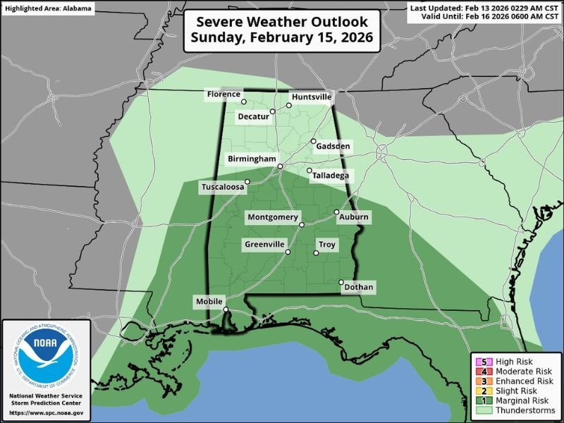
Marginal Severe Risk Near the Gulf Coast
The Storm Prediction Center has outlined a low-end “marginal risk” (Level 1 of 5) for severe thunderstorms extending as far north as Birmingham. However, current expectations suggest the primary severe window will remain confined to far South Alabama, especially near Mobile and Baldwin counties Sunday morning.
Within that coastal corridor, a few storms could briefly strengthen. That said, weakening dynamics and limited surface-based instability are expected to keep the overall severe threat relatively low. Meteorologists will continue monitoring conditions Sunday morning, particularly near the Gulf Coast, where any stronger thunderstorms would most likely develop.
Warmest Week of the Year Ahead
After Sunday’s rain, next week is shaping up to be the warmest stretch of the year so far. Forecast highs for much of Alabama will climb into the 70s, with some South Alabama communities potentially reaching the low 80s by midweek. The daily temperature outlook shows a steady warming trend from the mid-60s into the mid-to-upper 70s before slightly easing back later in the week.
Most of next week appears dry, although a few isolated showers could return by Friday. While this system remains centered well to the south of Illinois, NapervilleLocal.com tracks significant regional weather trends nationwide, as large-scale patterns across the Gulf Coast and Southeast often signal broader atmospheric shifts that can influence Midwest conditions in the weeks ahead.
Stay connected with NapervilleLocal.com for continued updates on major weather developments across the country.

I’ve lived in Naperville long enough to see how quickly our community changes — from new developments downtown to sudden shifts in our Midwest weather. Reporting on Naperville news and daily forecasts gives me the chance to keep neighbors informed about what really matters. My goal is simple: deliver clear, timely updates so you always know what’s happening in our city and what to expect from the skies above.