
Severe Weather Threat Targets Texas, Louisiana, Mississippi and the Gulf Coast on Saturday With Damaging Winds, Large Hail and Possible Tornadoes
UNITED STATES — A renewed round of severe weather is expected to erupt Saturday, February 14, 2026, across parts of Texas and the Deep South, with the greatest impacts shifting toward the Gulf Coast by evening and overnight.
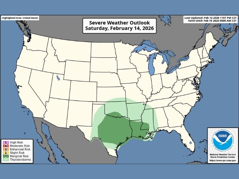
The latest Severe Weather Outlook map highlights a broad risk area stretching from central and eastern Texas into Louisiana, southern Arkansas, and much of Mississippi. Forecasters warn that damaging wind gusts, large hail, and even a couple of tornadoes will be possible as storms intensify late in the day.
Where the Risk Is Focused
The shaded risk area on the outlook map shows the highest concentration of concern centered over:
- Central and eastern Texas
- Western and southern Louisiana
- Southern Arkansas
- Most of Mississippi
- Portions of southwest Alabama
The Gulf Coast region — including areas near Houston, Lake Charles, Baton Rouge, New Orleans, Gulfport, and Biloxi — appears positioned for storms to continue into the overnight hours.
While not classified as a higher-end outbreak at this time, the setup supports organized thunderstorms capable of producing severe impacts.
Timing of the Strongest Storms
According to the forecast discussion included with the graphic, the most intense impacts are expected:
- Late Saturday afternoon across Texas
- Saturday evening across Louisiana and Mississippi
- Continuing overnight along the Gulf Coast
As daytime heating combines with strong upper-level energy, storms are expected to strengthen, especially as they move east and southeast. The Gulf Coast may see activity linger into the early morning hours Sunday.
Primary Hazards: What to Watch For
Forecasters are highlighting three main concerns:
Damaging Winds:
Strong thunderstorm cells could produce wind gusts capable of downing tree limbs and causing localized power outages.
Large Hail:
Some storms may generate hail large enough to damage vehicles and roofs, especially in stronger updraft zones.
Isolated Tornadoes:
While not expected to be widespread, a few tornadoes cannot be ruled out — particularly in areas closer to the Gulf Coast during the evening and overnight hours.
Residents in the highlighted states should remain alert for updated warnings as the system evolves.
Why This Matters
Severe weather this time of year can develop quickly and sometimes catch communities off guard, especially when activity extends into nighttime hours. Overnight tornadoes and wind events often pose greater safety risks because visibility is reduced and many people are asleep when warnings are issued.
With impacts expected to stretch from Texas through Mississippi and into coastal sections of Alabama, officials urge residents to monitor reliable weather sources and ensure they have multiple ways to receive alerts.
NapervilleLocal.com will continue tracking significant national weather systems that could have broader atmospheric implications and will provide updates as this weekend’s storm threat unfolds.

I’ve lived in Naperville long enough to see how quickly our community changes — from new developments downtown to sudden shifts in our Midwest weather. Reporting on Naperville news and daily forecasts gives me the chance to keep neighbors informed about what really matters. My goal is simple: deliver clear, timely updates so you always know what’s happening in our city and what to expect from the skies above.