
North Carolina Warms Into the 50s and Low 60s Saturday Before Evening Clouds and Rain Spread Statewide Into Sunday
NORTH CAROLINA — A quiet but gradually changing weather pattern is unfolding across the state this Saturday, with comfortable afternoon temperatures and increasing clouds signaling rain chances later tonight into Sunday.
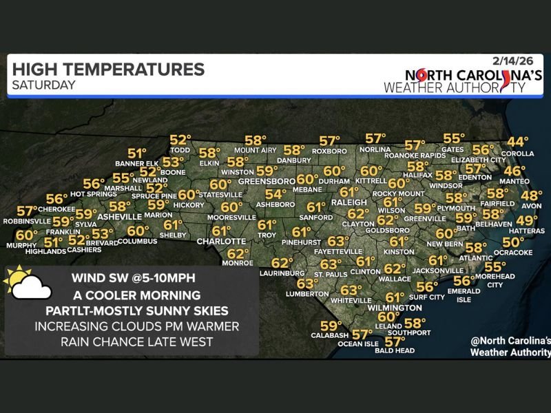
According to the latest statewide high temperature outlook, most of North Carolina will see afternoon highs in the 50s and low 60s, with warmer readings concentrated across central and southern counties.
Cooler in the Mountains, Mild in the Piedmont
Western North Carolina begins the day on the cooler side, especially in higher elevations.
Forecast highs include:
- Banner Elk: 51°F
- Boone: 52°F
- Newland: 52°F
- Spruce Pine: 52°F
- Brevard: 53°F
- Asheville: 58°F
- Franklin: 59°F
- Murphy: 60°F
- Shelby: 61°F
Temperatures gradually warm moving east into the foothills and Piedmont.
Central North Carolina Near 60 Degrees
Cities across the Triad and Triangle are expected to reach the upper 50s to low 60s under partly to mostly sunny skies before cloud cover increases late in the day.
Highs include:
- Greensboro: 59°F
- Winston-Salem: 58°F
- Mount Airy: 58°F
- Durham: 60°F
- Raleigh: 61°F
- Sanford: 61°F
- Asheboro: 54°F
- Mooresville: 60°F
- Charlotte: 61°F
- Monroe: 62°F
Light southwest winds at 5 to 10 mph will help nudge temperatures upward through the afternoon.
Warmest Readings in the South and Southeast
The mildest conditions are expected across southern and southeastern North Carolina, where several locations will touch the low 60s.
Forecast highs:
- Fayetteville: 63°F
- Lumberton: 63°F
- Whiteville: 63°F
- Clinton: 61°F
- Goldsboro: 62°F
- Kinston: 61°F
- Wilmington: 61°F
Cooler Along the Outer Banks
Coastal communities will run slightly cooler due to marine influence.
Highs include:
- Corolla: 44°F
- Manteo: 46°F
- Avon: 48°F
- Hatteras: 49°F
- Ocracoke: 50°F
- Elizabeth City: 56°F
- Morehead City: 55°F
- Emerald Isle: 56°F
Clouds Increase Late, Rain Moves In Tonight
While much of the day will feel calm and seasonable, changes arrive this evening. Moisture increases first across western North Carolina, with light rain possible late in the day in the mountains. Rain is expected to overspread much of the state overnight into Sunday as cloud cover thickens statewide.
Overall, Saturday offers a pleasant break before the wetter pattern takes hold. Residents across North Carolina can expect mild afternoon temperatures, a cooler start to the day, and growing cloud cover signaling rain on the way. For more detailed regional weather breakdowns and national outlook coverage, stay connected with NapervilleLocal.com.

I’ve lived in Naperville long enough to see how quickly our community changes — from new developments downtown to sudden shifts in our Midwest weather. Reporting on Naperville news and daily forecasts gives me the chance to keep neighbors informed about what really matters. My goal is simple: deliver clear, timely updates so you always know what’s happening in our city and what to expect from the skies above.