
Southwest Winds Push Tampa Bay Temperatures Into the 60s as Muggy February Conditions Bring Evening Rain Threat
Tampa, Florida — West-central Florida is experiencing an unseasonably warm February morning as southwest winds push temperatures into the 60s across the Tampa Bay region. The mild start comes with rising humidity and an increasing rain threat expected between 4 p.m. and midnight, signaling a shift in conditions later today.
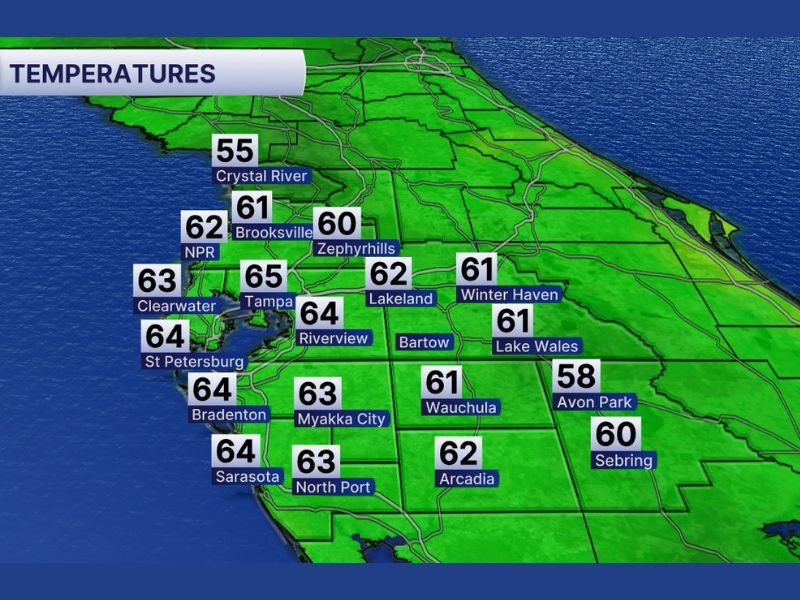
Across the region, temperature readings show consistent warmth. Tampa reached 65 degrees, while St. Petersburg, Bradenton, and Sarasota reported 64 degrees. Clearwater registered 63 degrees, and inland areas such as Lakeland, Winter Haven, and Wauchula hovered around 61 to 62 degrees. Even typically cooler Crystal River climbed to 55 degrees, confirming the broad influence of the warm air mass.
Southwest Winds Driving Unseasonable Warmth
The main driver behind today’s temperature surge is a steady southwest wind pattern. This wind direction transports warmer, moisture-rich air into west-central Florida, replacing cooler overnight air and creating a noticeably muggy February atmosphere.
Communities including Brooksville (61 degrees) and Zephyrhills (60 degrees) are seeing similar mild conditions. Farther south, North Port (63 degrees) and Arcadia (62 degrees) continue to reflect the widespread warming trend. Even Avon Park, at 58 degrees, remains comfortably mild for mid-winter standards.
The increase in humidity is especially notable. Residents may notice thicker air and increasing cloud cover throughout the day, typical signs that a weather system is approaching.
Rain Expected Late Afternoon Through Midnight
While the morning remains warm and relatively calm, conditions are expected to change later today. Forecasters indicate rain chances will build after 4 p.m., with showers possible through midnight.
Cities such as Lakeland and Winter Haven remain positioned ahead of the incoming disturbance. As clouds thicken, scattered showers may begin developing before spreading more broadly into the evening hours. Although no severe weather has been highlighted, brief periods of rain could create slick roadways and minor travel disruptions.
Residents with outdoor plans or evening travel should monitor updates and remain prepared for changing conditions.
This warm-and-wet pattern highlights Florida’s transitional February weather, where brief spring-like warmth can quickly give way to unsettled skies. For continued regional weather coverage and daily updates, visit NapervilleLocal.com.

I’ve lived in Naperville long enough to see how quickly our community changes — from new developments downtown to sudden shifts in our Midwest weather. Reporting on Naperville news and daily forecasts gives me the chance to keep neighbors informed about what really matters. My goal is simple: deliver clear, timely updates so you always know what’s happening in our city and what to expect from the skies above.