
Strong Cold Front Targets Tampa Bay With 35+ MPH Gusts This Afternoon and Potential 45 MPH Storm Winds Tonight
Tampa, Florida — Gusty conditions are building across the Tampa Bay region as a strong cold front approaches, with winds expected to exceed 35 mph this afternoon and potentially surpass 45 mph tonight in stronger storms. Forecasters indicate the windiest period will occur ahead of and along the frontal boundary as it sweeps through west-central Florida.
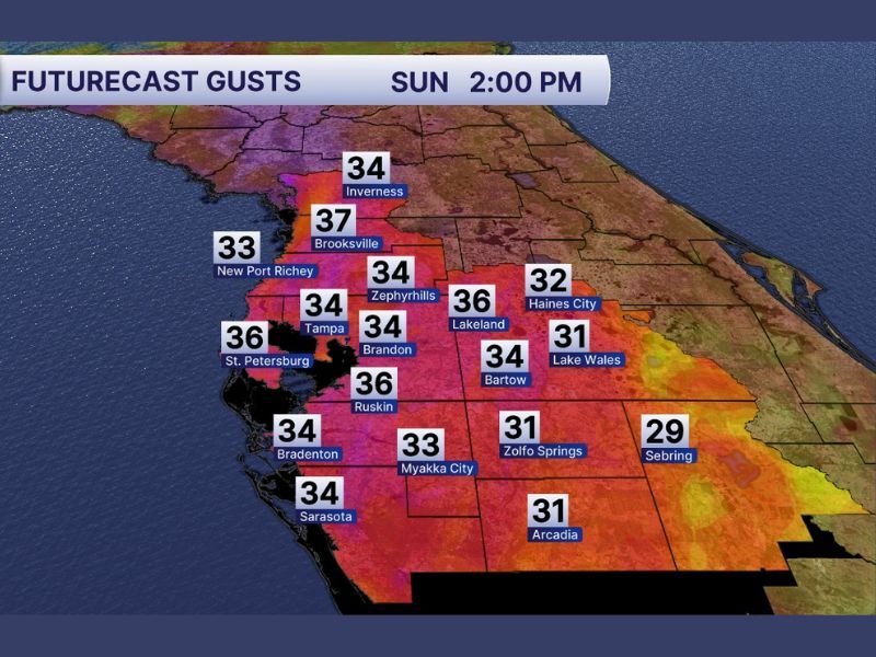
Future wind projections for Sunday at 2:00 p.m. show widespread gusts in the 30 to upper 30 mph range across the region. Communities north of Tampa are expected to see some of the strongest sustained gusts.
Afternoon Gusts Already Climbing Into the Upper 30s
Wind forecasts show Brooksville peaking near 37 mph, one of the highest projected readings in the area. Lakeland and Ruskin are expected to reach 36 mph, while St. Petersburg also sees gusts around 36 mph.
Other communities across the Tampa Bay corridor, including Tampa (34 mph), Brandon (34 mph), Zephyrhills (34 mph), and Sarasota (34 mph), remain firmly within the 30 mph range. Coastal areas such as New Port Richey (33 mph) and inland spots like Myakka City (33 mph) are also forecast to experience steady gusty winds.
Further inland, slightly lower but still breezy conditions are projected in Haines City (32 mph), Lake Wales (31 mph), Arcadia (31 mph), and Zolfo Springs (31 mph). Sebring may see gusts near 29 mph, slightly below the regional peak but still elevated.
Stronger Storm Winds Possible Tonight
As the cold front arrives tonight, meteorologists warn that embedded thunderstorms could produce wind gusts exceeding 45 mph in localized areas. While the afternoon period remains primarily windy without severe weather, the frontal passage could bring a brief window of stronger convective activity.
These higher gusts may be capable of downing small tree limbs, causing isolated power outages, and creating hazardous travel conditions on bridges and elevated roadways. Loose outdoor items could also be displaced if not secured.
The strongest winds will likely coincide with the line of showers and storms along the advancing front. Timing of the frontal arrival will determine which communities see the most intense conditions, but the entire Tampa Bay area should prepare for a breezy and potentially stormy evening.
Residents are encouraged to secure lightweight outdoor furniture, use caution while driving high-profile vehicles, and stay updated on local weather alerts as the front moves through.
This active wind pattern underscores how quickly conditions can change ahead of a frontal system in Florida. For continued updates on significant weather developments across the country, visit NapervilleLocal.com for comprehensive reporting and regional analysis.

I’ve lived in Naperville long enough to see how quickly our community changes — from new developments downtown to sudden shifts in our Midwest weather. Reporting on Naperville news and daily forecasts gives me the chance to keep neighbors informed about what really matters. My goal is simple: deliver clear, timely updates so you always know what’s happening in our city and what to expect from the skies above.