
Tornado Threat Targets Southern Illinois, Southern Indiana and Southwest Ohio as Severe Storms Sweep the Ohio Valley Today
OHIO VALLEY — Severe weather is likely today across the region, with damaging winds, large hail, and a few tornadoes possible this afternoon. The most favorable area for tornado development stretches across southern Illinois, southern Indiana, and southwest Ohio, where atmospheric conditions are expected to align for stronger storms.
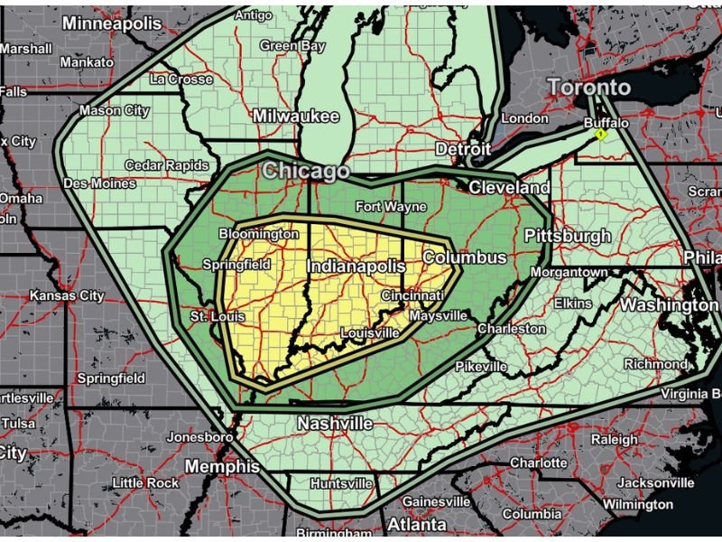
Highest Tornado Risk Centered Near Southern Illinois, Southern Indiana and Southwest Ohio
The most concentrated severe weather zone extends from St. Louis and southern Illinois, across southern Indiana including Bloomington and areas near Indianapolis, and into Cincinnati and southwest Ohio.
Cities highlighted within the higher-risk zone include:
- St. Louis, Missouri
- Springfield, Illinois
- Bloomington, Indiana
- Indianapolis, Indiana
- Louisville, Kentucky
- Cincinnati, Ohio
- Columbus, Ohio
This corridor falls inside the more focused risk area on the outlook map, indicating the best overlap of instability and wind shear needed for organized severe storms and possible tornadoes.
Damaging Winds and Large Hail Also Expected
While tornadoes are the primary concern in the highlighted zone, damaging straight-line winds and large hail may affect a broader portion of the Ohio Valley.
Areas included in the wider severe outlook include:
- Chicago, Illinois
- Milwaukee, Wisconsin
- Detroit, Michigan
- Cleveland, Ohio
- Pittsburgh, Pennsylvania
- Nashville, Tennessee
- Memphis, Tennessee
Strong thunderstorms will likely increase in coverage through the afternoon before pushing east into the evening hours.
Storm Motion and Timing
Storms are expected to move from west to east across Illinois, Indiana, and Ohio. The greatest severe threat will occur during the afternoon and early evening when atmospheric conditions become most supportive of rotating storms.
Forecasters note that the tornado threat appears highest along and south of the primary corridor through southern Illinois and southern Indiana into southwest Ohio.
Residents Urged to Stay Weather-Aware
Those living within the highlighted tornado zone should:
- Monitor weather alerts throughout the afternoon
- Have multiple ways to receive warnings
- Review safety plans in advance
Warnings may be issued quickly if storms intensify or show signs of rotation. For continuing coverage of severe weather across the Midwest and Ohio Valley, stay connected with NapervilleLocal.com for updates throughout the day.

I’ve lived in Naperville long enough to see how quickly our community changes — from new developments downtown to sudden shifts in our Midwest weather. Reporting on Naperville news and daily forecasts gives me the chance to keep neighbors informed about what really matters. My goal is simple: deliver clear, timely updates so you always know what’s happening in our city and what to expect from the skies above.