
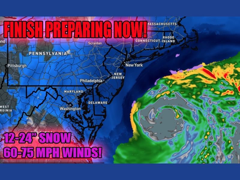
Dangerous Nor’easter Targets Pennsylvania, New Jersey, New York and New England With 12–24 Inches of Snow and 60–75 MPH Hurricane-Force Gusts
UNITED STATES — A powerful and potentially life-threatening Nor’easter is intensifying along the East Coast, with conditions expected to rapidly deteriorate from Pennsylvania and New Jersey through New York and into New England. Forecasters are urging residents to finish preparations immediately, warning that snowfall rates and wind speeds could create full blizzard conditions by tonight.
The storm is forecast to produce 12 to 24 inches of snow across a large portion of the region, combined with 60 to 75 mph wind gusts in the hardest-hit coastal and near-coastal areas.
Conditions Expected to Worsen Rapidly This Afternoon
The latest radar simulation and forecast guidance show the storm strengthening offshore while spreading heavy snow inland from the Mid-Atlantic into southern New England. Areas including Philadelphia, New York City, northern New Jersey, Connecticut, and parts of Massachusetts are in the corridor most likely to experience intense snowfall rates.
Meteorologists warn that conditions will begin declining this afternoon and ramp up to dangerous levels tonight, particularly as winds intensify and snowfall rates increase.
Blizzard Conditions Likely in Coastal and Metro Areas
With sustained strong winds and gusts reaching hurricane-force levels (60–75 mph) in some locations, whiteout conditions are likely during peak intensity. Blowing and drifting snow could make roads impassable, especially in exposed areas.
The combination of heavy snow and extreme wind raises the risk of:
- Near-zero visibility
- Downed tree limbs and scattered power outages
- Rapid snow accumulation on highways
- Severe coastal travel disruptions
Travel Strongly Discouraged Across the Northeast
Officials and forecasters are making it clear: Travel is not advised. While emergency workers and essential personnel may need to be on the roads, the general public is urged to stay home once conditions worsen.
Major corridors including interstates around Philadelphia and New York City, as well as regional and international airports, are expected to face significant disruptions. The storm’s intensity suggests recovery from cancellations and delays could take several days.
A High-Impact Storm for the Region
This Nor’easter is shaping up to be one of the more intense winter systems in recent years for parts of the Northeast. The combination of 1–2 feet of snow and damaging winds will create hazardous conditions well into early week.
Residents in the affected states should complete storm preparations immediately and monitor official updates as warnings and advisories evolve. For continued coverage of major national weather events and in-depth storm analysis, follow updates on NapervilleLocal.com.

I’ve lived in Naperville long enough to see how quickly our community changes — from new developments downtown to sudden shifts in our Midwest weather. Reporting on Naperville news and daily forecasts gives me the chance to keep neighbors informed about what really matters. My goal is simple: deliver clear, timely updates so you always know what’s happening in our city and what to expect from the skies above.