
Lake Effect Snow Targets Berrien County With 6–9+ Inches as 35 MPH Winds Create Blowing Snow Across Michigan
UNITED STATES — Lake effect snow continues across much of Michigan today, with the heaviest and most persistent banding expected in Berrien County, where snowfall totals could exceed 6 to 9 inches and potentially reach 12 inches or more before the system winds down.
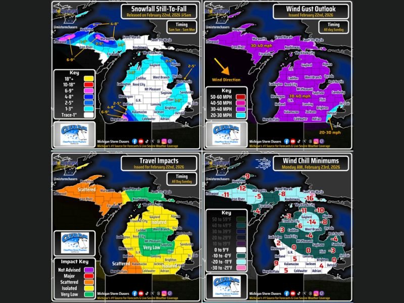
Forecast maps show varying snowfall zones across the state, driven by northwest winds off Lake Michigan.
Snowfall Breakdown by Region
Accumulations will vary widely depending on lake effect band placement:
- White zone: Up to 1 inch in passing snow showers
- Light blue: 1–3 inches possible, even into parts of southeast Michigan
- Medium blue: 2–5 inches
- Darker blue: 4–8 inches
- Pink zone: 6–9 inches or more
The most dominant lake effect band is expected to remain focused near Berrien County and far southwest Michigan, making that region the likely snowfall “winner” today.
Gusty Northwest Winds Increase Impacts
Winds will be gusting between 30 and 35 mph across much of Michigan, particularly during the afternoon and evening. These northwest winds will:
- Enhance lake effect snow bands
- Cause blowing and drifting snow
- Reduce visibility at times
Even areas with lighter snowfall totals could experience brief low-visibility conditions when gusts align with active snow showers.
Travel Conditions: Scattered to Isolated Impacts
Travel impact guidance suggests:
- Orange zones (Upper Peninsula and southwest Michigan): Scattered travel impacts likely, especially where snow is heavier and more consistent.
- Yellow zones (northern Lower Michigan and portions of southeast Michigan): Isolated impacts possible, mainly during bursts of heavier snow.
- Green zones: Very low travel impact, with lighter snow expected to melt or accumulate minimally.
Drivers should remain alert for rapidly changing road conditions, particularly in lake effect corridors where snowfall rates can spike quickly.
Bitter Cold Returns Monday Morning
The cold does not end with the snow. Wind chill forecasts for Monday morning show temperatures dropping below zero across a large portion of Michigan.
Projected wind chill minimums include:
- Northern Lower and Upper Peninsula: -8°F to -16°F
- Central Michigan: -4°F to -11°F
- Southern Michigan: Single digits above zero, with some spots near or slightly below zero
These wind chills could linger in the mornings throughout the upcoming week.
What to Expect Next
Lake effect snow will gradually shift and weaken, but gusty conditions and cold air will remain in place. Residents in southwest Michigan, especially in and around Berrien County, should prepare for higher snow totals and reduced visibility at times.
For continued coverage of major weather systems and regional forecast analysis, stay updated with NapervilleLocal.com.

I’ve lived in Naperville long enough to see how quickly our community changes — from new developments downtown to sudden shifts in our Midwest weather. Reporting on Naperville news and daily forecasts gives me the chance to keep neighbors informed about what really matters. My goal is simple: deliver clear, timely updates so you always know what’s happening in our city and what to expect from the skies above.