
Texas and Oklahoma Prepare for Two Rounds of Severe Storms With Hail, Damaging Winds and Possible Tornadoes This Week
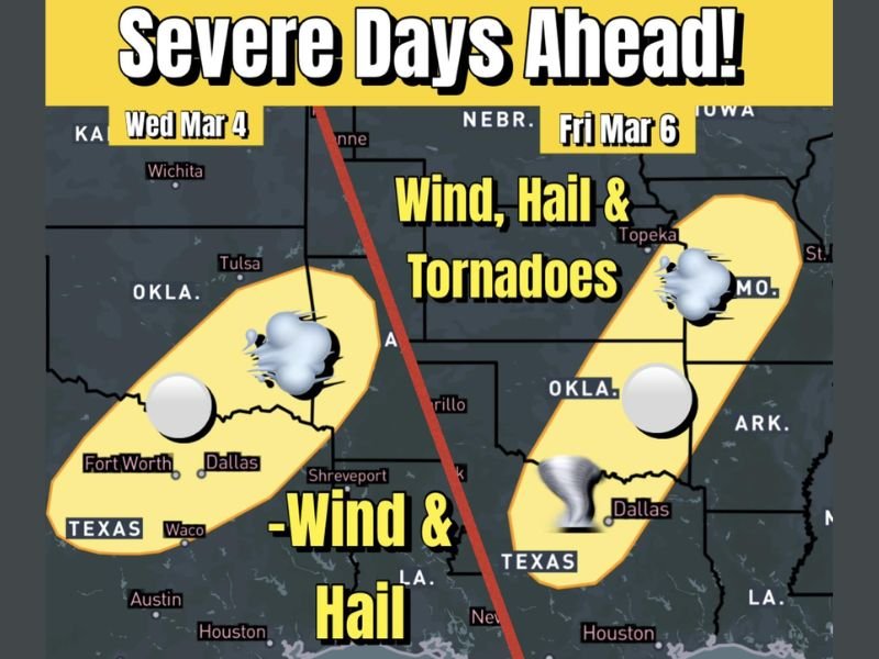
TEXAS AND OKLAHOMA — A strengthening spring weather pattern is setting up two separate rounds of severe storms this week across north Texas and Oklahoma, bringing threats of large hail, damaging wind gusts, and possible tornado development on Wednesday and again Friday. Forecasters identify Wednesday (March 4) as the first active day, followed by a broader and slightly more volatile setup on Friday (March 6), with both events targeting similar regions.
Wednesday: Hail and Damaging Winds From North Texas Into Oklahoma
Storm development is expected across north Texas, including areas near Dallas, Fort Worth, and Waco, before extending northward into parts of Oklahoma, including regions near Tulsa. Meteorologists indicate that hail and strong straight-line winds will be the primary hazards during Wednesday’s activity. Thunderstorms may rapidly intensify during the afternoon and evening as unstable air combines with favorable upper-level dynamics. Some storms could produce hail large enough to cause damage to vehicles, roofs, and outdoor property.
While tornado potential appears limited during this first round, isolated rotation cannot be completely ruled out. The atmospheric setup favors strong hail-producing storms rather than widespread tornado activity. Residents across the highlighted risk corridor are advised to stay weather-aware and monitor local alerts as conditions evolve through the day.
Friday: Expanded Risk With Added Tornado Potential
By Friday (March 6), the severe weather setup broadens geographically and becomes slightly more dynamic. The risk zone stretches across north Texas and Oklahoma, expanding toward portions of Kansas and Missouri, including areas near Topeka. Hail and damaging winds remain the dominant concerns, but forecasters note that increasing wind shear and instability may introduce a greater chance for a few tornadoes if rotating supercell storms develop.
Friday’s system is expected to impact a larger area compared to Wednesday’s event, and some locations could experience multiple rounds of storms. The combination of warm, moist air from the Gulf and strengthening upper-level winds creates an environment more supportive of rotating thunderstorms. Although tornado development is not expected to be widespread, even a few isolated tornadoes could produce significant localized impacts.
Spring Severe Season Is Underway
This two-day severe pattern signals the beginning of a more active spring storm season across the Southern Plains. Early March often marks a transition toward stronger storm systems as seasonal temperature contrasts sharpen and atmospheric dynamics strengthen. The presence of instability, wind shear, and surface low-pressure systems creates the classic ingredients for hail, damaging winds, and tornadoes.
Back-to-back severe weather days are a clear sign that the atmosphere is becoming more primed for organized storm development. Residents across affected regions should ensure they have multiple ways to receive warnings, particularly during evening hours when storms can intensify quickly. As spring continues, similar setups may become more frequent across the central United States.
For ongoing weather coverage and regional updates, visit NapervilleLocal.com for reliable reporting and detailed analysis.

I’ve lived in Naperville long enough to see how quickly our community changes — from new developments downtown to sudden shifts in our Midwest weather. Reporting on Naperville news and daily forecasts gives me the chance to keep neighbors informed about what really matters. My goal is simple: deliver clear, timely updates so you always know what’s happening in our city and what to expect from the skies above.