
Damaging Winds, Large Hail, and Tornadoes Possible Across Wichita, Omaha, Kansas City, and Minneapolis Thursday April 23 as Slight Risk Covers Central US
CENTRAL UNITED STATES — Severe weather chances will increase significantly across the central United States on Thursday April 23, 2026, as a Slight Risk Level 2 out of 5 is in place for a broad corridor covering major cities including Wichita, Omaha, Kansas City, Des Moines, and Minneapolis.
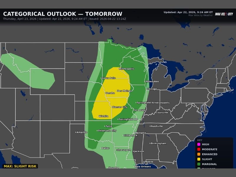
The Categorical Outlook issued by Max Velocity Weather shows the Slight Risk zone centered across Iowa, Nebraska, Kansas, and Minnesota, with damaging winds, large hail, and a few tornadoes all possible as storms develop through the afternoon and evening hours.
Slight Risk Zone Covers Iowa, Nebraska, Kansas, and Minnesota
The Thursday outlook map places the core Slight Risk zone across a corridor stretching from Minneapolis and Sioux Falls southward through Omaha, Des Moines, Kansas City, and Wichita. This yellow Slight Risk zone indicates a meaningful probability of organized severe weather development across all highlighted communities during the Thursday afternoon and evening storm window.
A broader Marginal Risk zone surrounds the core Slight Risk area, extending the overall severe weather footprint outward to cover portions of Wisconsin, Illinois, Missouri, Oklahoma, and Texas. Cities including Milwaukee, Chicago, Springfield IL, St. Louis, Tulsa, Oklahoma City, and Dallas all fall within or near the outer Marginal Risk zone for Thursday.
Damaging Winds, Large Hail, and Tornadoes All in Play
Three distinct severe weather hazards are associated with Thursday’s developing storm system across the central United States. Damaging wind gusts represent the most widespread threat across the Slight Risk corridor, with the potential for straight-line wind damage extending broadly as storms organize into more linear modes through the evening hours.
Large hail is the second significant hazard, particularly during the early supercell phase of storm development before any squall line transition occurs. A few tornadoes round out the threat picture, with the tornado potential most pronounced across the core of the Slight Risk zone where the atmospheric setup is most favorable for rotating storm development during the afternoon hours.
Storms Develop Through Afternoon and Evening
The Thursday severe weather window opens during the afternoon hours and extends through the evening as storms develop along the sharp dryline pushing eastward across the central Plains. Initial storm development is expected to begin during the mid to late afternoon before becoming more widespread and organized through the early evening hours across the Slight Risk corridor.
Residents across Wichita, Omaha, Kansas City, Des Moines, and Minneapolis should have all preparations finalized before the afternoon storm window opens Thursday and remain weather aware through the evening hours as the system continues to evolve across the region. Stay with NapervilleLocal.com for the latest weather updates and local forecast coverage.

I’ve lived in Naperville long enough to see how quickly our community changes — from new developments downtown to sudden shifts in our Midwest weather. Reporting on Naperville news and daily forecasts gives me the chance to keep neighbors informed about what really matters. My goal is simple: deliver clear, timely updates so you always know what’s happening in our city and what to expect from the skies above.