
Florida Temperatures Set to Stay 5 to 10 Degrees Above Normal Through Mid-March With No Cold Air in Sight
FLORIDA — A prolonged stretch of warmer-than-average temperatures is expected to continue across the state over the next 10 to 15 days, with forecasters reporting no signs of meaningful cold air returning through at least March 15. High temperatures are projected to run 5 to 10 degrees above seasonal averages, signaling a steady early taste of late-spring conditions.
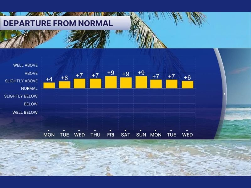
The extended outlook shows consistent positive departures from normal temperatures throughout the period. While record-breaking heat is not expected, the pattern favors persistent warmth across much of the region.
Daily Temperature Departures Remain Elevated
Forecast data indicates that temperatures will begin the stretch around 4 degrees above normal on Monday, then climb to 6 to 7 degrees above average midweek. By Friday, Saturday, and Sunday, departures are expected to peak near 9 degrees above normal, marking the warmest portion of the pattern.
Even into the following week, readings are projected to remain elevated, hovering around 7 degrees above average on Monday and Tuesday, before easing slightly to around 6 degrees above normal by Wednesday. This consistent upward deviation highlights a stable warm-air pattern dominating the region.
Importantly, there are no strong signals in the extended forecast showing a push of cold air capable of resetting temperatures back to seasonal norms. The absence of significant northern air intrusions suggests the warm regime will hold steady.
What the Pattern Means for Mid-March
Although this stretch does not appear extreme enough to challenge long-standing heat records, sustained temperatures above average can still influence daily life. Warmer afternoons may increase early-season cooling demand and accelerate seasonal transitions across the state.
The steady warmth also reflects a broader atmospheric setup favoring high pressure and limited cold front penetration. Without strong frontal boundaries moving through, temperature swings remain minimal, allowing daytime highs to consistently trend above normal levels.
Meteorologists note that early March can often feature fluctuating patterns, but this outlook suggests a more locked-in setup. With temperatures holding 5 to 10 degrees above average for nearly two weeks, the overall feel will be noticeably warmer than typical early-March conditions.
Residents should plan for continued mild mornings and warm afternoons through mid-month. While not extreme, the persistent nature of the warmth is the key headline, as it reduces the likelihood of any late-winter cooldown before mid-March arrives.
For continued updates on significant weather patterns and regional outlooks, visit NapervilleLocal.com for the latest reports and forecasts.

I’ve lived in Naperville long enough to see how quickly our community changes — from new developments downtown to sudden shifts in our Midwest weather. Reporting on Naperville news and daily forecasts gives me the chance to keep neighbors informed about what really matters. My goal is simple: deliver clear, timely updates so you always know what’s happening in our city and what to expect from the skies above.