
Alabama Enters Peak Tornado Season as March Risk Expands From Dallas–Fort Worth to Kansas City and Southeast Pattern Turns Active
ALABAMA — March has arrived, and with it comes one of the most active periods of the year for severe weather across the state. While Alabama’s tornado season technically runs from November through May, historical data shows that March and April rank among the most active months, making early spring a critical time for preparedness.
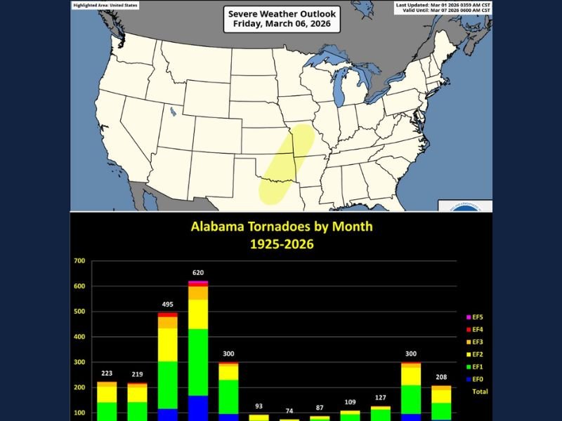
The Storm Prediction Center (SPC) has already outlined a risk of severe storms for Friday, March 6, stretching in a broad corridor from Dallas–Fort Worth through Oklahoma and into Kansas City. While that risk area is currently centered west of Alabama, meteorologists note that evolving upper-level patterns across the Southeast could open the door for more active weather locally as the weekend or following week unfolds.
March and April Historically Active for Alabama Tornadoes
Long-term tornado data from 1925 through 2026 shows March as one of Alabama’s more prolific months for tornado activity. The chart highlights nearly 500 tornadoes recorded in March, with April historically leading the year at more than 600 total events.
These figures underscore why March is treated seriously across the state. The combination of strengthening Gulf moisture, increasing wind shear, and shifting jet stream patterns creates a favorable environment for rotating storms.
Unlike the traditional “Tornado Alley” peak later in spring, Alabama’s severe season often ramps up earlier. Storm systems tracking out of Texas and the Southern Plains frequently move eastward, influencing the Deep South within days.
SPC Day 6 Outlook Signals Broader Pattern Shift
The SPC’s Day 6 severe outlook for Friday includes portions of north Texas, Oklahoma, Kansas, and Missouri, indicating increasing confidence in organized thunderstorms later this week. The highlighted zone includes major cities such as Dallas, Fort Worth, Oklahoma City, Tulsa, and Kansas City.
While Alabama is not currently inside the outlined Friday risk zone, meteorologists emphasize that upper-level high pressure breaking down across the Southeast could allow more active weather to develop closer to home over the weekend or into the following week.
This pattern shift is important. When disturbances repeatedly move across the Southern Plains and Mid-South, downstream impacts into Alabama often follow as moisture and instability return northward from the Gulf.
Preparedness Is Critical During Peak Season
With March historically active, forecasters are urging residents to review severe weather safety plans now. Every Alabama home and business should have access to a NOAA Weather Radio, which remains a baseline tool for receiving warnings.
Families should identify a safe place within the home — ideally an interior room on the lowest floor away from windows — and ensure everyone knows where to go if a warning is issued. Helmets for each family member can provide additional protection during tornado emergencies.
For residents in mobile homes, knowing the location of the nearest shelter and having transportation arranged in advance is especially important on severe weather days.
Getting the warning and having a plan remain the two keys to protecting lives during Alabama’s tornado season. As March begins and atmospheric patterns turn more active across the region, vigilance and preparation are more important than ever.
For continued coverage of severe weather trends and regional updates, visit NapervilleLocal.com for the latest reports and preparedness information.

I’ve lived in Naperville long enough to see how quickly our community changes — from new developments downtown to sudden shifts in our Midwest weather. Reporting on Naperville news and daily forecasts gives me the chance to keep neighbors informed about what really matters. My goal is simple: deliver clear, timely updates so you always know what’s happening in our city and what to expect from the skies above.