
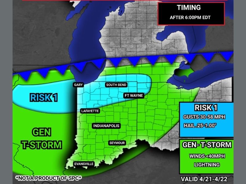
Gusty Winds and Small Hail Possible Across Northern Indiana Including Gary, South Bend, and Fort Wayne After 6 PM Tuesday With Risk Shifting South Overnight
NORTHERN INDIANA — A few thunderstorms are possible later this evening across northern Indiana, with some storms capable of gusty winds and small hail after 6 PM EDT. Severe weather is not expected with tonight’s activity, but a Risk 1 designation has been issued for the northern tier of the state including Gary, South Bend, and Fort Wayne where the best chances for small hail and gusty winds exist. Overnight the storm threat shifts southward across central and southern Indiana as mostly rain with embedded thunderstorms continues through the night.
Risk 1 Zone Covers Northern Indiana After 6 PM
The IWO Severe Outlook valid April 21 to 22 places a Risk 1 zone across the northern Indiana corridor including Gary, South Bend, and Fort Wayne. This zone carries the highest storm potential of tonight’s outlook, with wind gusts of 30 to 58 MPH and hail up to one inch in diameter possible with the stronger cells that develop after 6 PM EDT.
The Risk 1 designation indicates a lower end severe threat where impacts will be localized rather than widespread, but residents across the northern Indiana zone should remain weather aware through the evening hours as storms develop and push through the region.
General Thunderstorm Zone Covers Central and Southern Indiana
The broader green General Thunderstorm zone extends across the remainder of Indiana including Indianapolis, Lafayette, Seymour, and Evansville. This zone carries a lower threat level with winds staying below 40 MPH and lightning being the primary concern rather than any significant severe weather hazard.
Mostly rain with embedded thunderstorm activity will be the dominant weather type across central and southern Indiana through the evening and overnight hours, with no severe weather expected across this broader zone.
Overnight Risk Shifts South Across Central and Southern Indiana
As the evening progresses into overnight hours, the thunderstorm risk shifts southward across central and southern Indiana. The activity is expected to remain below severe thresholds as it pushes into the southern portions of the state, continuing as mostly rain with embedded lightning and thunder rather than organized severe storm activity.
Residents across Indianapolis, Seymour, and Evansville should expect the overnight thunderstorm activity to arrive after the initial northern Indiana evening window, with conditions gradually improving as the system pushes east and southeast through the overnight hours. Stay with NapervilleLocal.com for the latest weather updates and local forecast coverage.

I’ve lived in Naperville long enough to see how quickly our community changes — from new developments downtown to sudden shifts in our Midwest weather. Reporting on Naperville news and daily forecasts gives me the chance to keep neighbors informed about what really matters. My goal is simple: deliver clear, timely updates so you always know what’s happening in our city and what to expect from the skies above.