
Oklahoma and North Texas Marked for Back-to-Back Severe Weather Risks on March 4 and March 6 as Active Pattern Takes Hold
OKLAHOMA AND NORTH TEXAS — An active early-March weather pattern is taking shape across the Southern Plains, with forecasters monitoring two separate severe weather windows this week — Wednesday, March 4, and Friday, March 6.
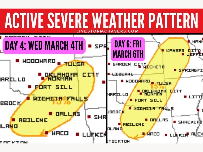
The highlighted risk areas center on north Texas and much of Oklahoma, signaling growing concern that organized thunderstorms could develop on both days as disturbances move through the region.
Day 4: Wednesday, March 4 Targets North Texas and Central Oklahoma
The first potential severe weather setup is outlined for Wednesday (March 4). The risk corridor includes Dallas, Waco, Abilene, Wichita Falls, Fort Sill, Oklahoma City, Norman, and Tulsa.
The broad 15% severe probability area stretches from central and north Texas northward into central Oklahoma, suggesting conditions may support strong thunderstorms capable of producing damaging impacts.
This setup reflects the beginning of a more energetic pattern for the region. While specific storm modes and exact hazards will become clearer closer to the event, the placement of key metro areas inside the outlook highlights the need for close monitoring.
Forecasters are watching how moisture return and upper-level dynamics evolve leading into midweek, as even subtle changes can affect storm coverage and intensity.
Day 6: Friday, March 6 Expands Risk Zone Northward
Attention then turns to Friday, March 6, when the severe risk area expands and shifts slightly north and east. The Friday outlook includes Abilene, Dallas, Waco, Wichita Falls, Fort Sill, Oklahoma City, Norman, Tulsa, Wichita, Springfield, and Kansas City.
This elongated risk zone stretches from north-central Texas through Oklahoma and into southern Kansas and western Missouri, again highlighting a 15% probability area for severe storms.
The broader footprint suggests a stronger or more expansive system may be organizing by late week. With two separate disturbances moving through within a short timeframe, atmospheric conditions may remain primed for organized thunderstorm development.
Two Systems in One Week Signal Active Start to March
Meteorologists are currently tracking two distinct weather events within the same week, underscoring the start of a more active severe weather pattern for early March.
When multiple disturbances track across the Southern Plains in succession, the environment often becomes increasingly favorable for strong storms. Each system can reinforce moisture return, enhance wind shear, and contribute to instability.
Although both events remain several days away and details will continue to evolve, the dual risk outlooks indicate that residents across north Texas, central and eastern Oklahoma, southern Kansas, and western Missouri should stay weather-aware throughout the week.
Early March often marks the beginning of a ramp-up in severe weather across the Southern Plains, and this pattern appears consistent with that seasonal transition.
For continued updates on developing storm risks and regional weather trends, visit NapervilleLocal.com for the latest reports and preparedness information.

I’ve lived in Naperville long enough to see how quickly our community changes — from new developments downtown to sudden shifts in our Midwest weather. Reporting on Naperville news and daily forecasts gives me the chance to keep neighbors informed about what really matters. My goal is simple: deliver clear, timely updates so you always know what’s happening in our city and what to expect from the skies above.