
Georgia Marks Start of Meteorological Spring With Widespread Mid-to-Upper 70s Today Before Overnight Cold Front Triggers Cooler “Wedge” Pattern
GEORGIA — Meteorological spring is officially underway, and much of the state is enjoying a warm and pleasant day before a cold front slides in tonight, ushering in noticeably cooler air for the next couple of days.
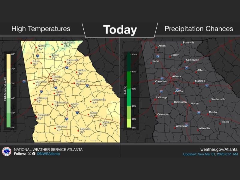
Afternoon high temperatures across north and central Georgia are climbing into the mid to upper 70s, marking a beautiful start to March. However, forecasters indicate this warmth will be short-lived as a front currently positioned to the north pushes southward later tonight.
Warm 70s Across Much of the State Today
Communities across the Atlanta metro area and beyond are seeing highs in the mid to upper 70s, including Atlanta near 76°, Athens around 78°, Madison at 76°, and Gainesville near 75°.
Farther west and south, temperatures are similarly warm. Carrollton is near 75°, Griffin around 76°, LaGrange at 76°, Columbus near 78°, and Americus around 76°. In central Georgia, Macon is near 77°, Dublin around 77°, and Vidalia close to 77°.
The overall pattern today reflects mild southwest flow ahead of the approaching boundary. Skies remain mostly clear to partly cloudy, and precipitation chances remain low during daylight hours.
Cold Front Moves In Tonight
That changes after sunset. A cold front positioned to the north will move into Georgia tonight, shifting winds and beginning a transition to cooler conditions. The frontal passage is expected to increase cloud cover and introduce higher rain chances, particularly late tonight into early Monday.
As the boundary settles southward, temperatures will drop into the upper 40s and 50s across much of the state. Cooler air behind the front will set the stage for what forecasters often refer to as “The Wedge” pattern.
Cooler Days Ahead With “The Wedge”
“The Wedge” is a setup where cooler, stable air becomes trapped near the surface east of the Appalachian Mountains. When this pattern develops, temperatures often remain lower than average, especially across north and central Georgia.
Following today’s spring-like warmth, highs over the next couple of days are expected to trend cooler compared to Sunday’s 70s. Cloud cover and lingering precipitation chances may also limit daytime warming.
While no significant severe weather is highlighted with this frontal passage, the primary story is the sharp temperature contrast from today’s warm and sunny conditions to a cooler, more stable pattern early in the week.
Residents should enjoy the pleasant weather today before the transition begins tonight. For continued updates on regional weather changes and detailed outlooks, visit NapervilleLocal.com for the latest reports and forecasts.

I’ve lived in Naperville long enough to see how quickly our community changes — from new developments downtown to sudden shifts in our Midwest weather. Reporting on Naperville news and daily forecasts gives me the chance to keep neighbors informed about what really matters. My goal is simple: deliver clear, timely updates so you always know what’s happening in our city and what to expect from the skies above.