
Denver and Colorado Front Range Brace for Windy Monday, Mountain Snow Tuesday as Late-Week System Looms
COLORADO — A warm but increasingly windy Monday is unfolding across Denver and the Front Range, with stronger southwest winds building in the mountains and foothills ahead of a developing storm system that will arrive late tonight into Tuesday.
Temperatures across eastern Colorado are climbing into the upper 60s and low 70s this afternoon, giving much of the region a mild start to the week. However, changing conditions are already underway as the next disturbance approaches from the northwest.
Warm Today, But Winds Increase in the Mountains and Foothills
Across the higher terrain, southwest winds are running between 5 and 15 mph, with gusts reaching 25 to 35 mph, and potentially up to 45 mph above 8,000 feet. These gusty conditions are most noticeable along the western slope and in foothill communities.
Elsewhere along the Front Range and eastern plains, south winds are generally 5 to 15 mph, with gusts up to 25 mph. While not extreme, the breezy pattern is a signal of the system pushing closer.
The warm air in place today is expected to shift quickly once the front arrives overnight.
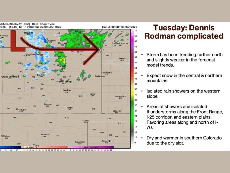
Storm Drops In Late Tonight Into Tuesday
The incoming system is forecast to move in from the northwest late tonight, spreading rain showers, isolated thunderstorms and high mountain snow across western and northern Colorado.
Snow is expected primarily in the central and northern mountains, including areas along and west of the Continental Divide. The western slope may see scattered rain showers that are not expected to produce heavy totals.
Along the Front Range, the I-25 corridor and eastern plains, scattered showers and isolated thunderstorms are likely Tuesday, especially in areas along and north of Interstate 70, including near the Palmer Divide.
Cooler North, Warmer South
Northern Colorado will feel the cooler air more noticeably Tuesday, with highs mainly in the 40s and 50s. Meanwhile, southern Colorado is expected to remain somewhat warmer and drier for a time due to a temporary dry slot ahead of the front, with temperatures climbing into the 60s and possibly low 70s before cooler air filters south.
Northerly winds are expected to increase Tuesday, running 5 to 15 mph with gusts up to 25 mph, reinforcing the cooler feel.
The system is forecast to exit late Tuesday night, bringing drier conditions by Wednesday.
Another System Late Week
Attention then turns to a more organized system expected late Thursday into Friday. Early signals suggest additional mountain snow, and depending on how the front evolves, rain and possibly snow could reach lower elevations.
Forecast confidence decreases into next week, with model solutions showing varying outcomes. For now, the upcoming weekend appears dry, but adjustments may be necessary as new data comes in. For continued updates on changing weather patterns across Colorado and beyond, visit NapervilleLocal.com for the latest coverage and forecasts.

I’ve lived in Naperville long enough to see how quickly our community changes — from new developments downtown to sudden shifts in our Midwest weather. Reporting on Naperville news and daily forecasts gives me the chance to keep neighbors informed about what really matters. My goal is simple: deliver clear, timely updates so you always know what’s happening in our city and what to expect from the skies above.